logo

1854. Map No. 1. From Fort Smith to the Rio Grande from explorations and surveys made under the direction of Hon. Jefferson Davis, Secretary of War By Lieut A.W. Whipple . . . and Lieut J.C. Ives, Topogl Engrs . . .1853-4

  • Map No. 1.  From Fort Smith to the Rio Grande from explorations and surveys made under the direction of Hon. Jefferson Davis, Secretary of War By Lieut A.W. Whipple . . . and Lieut J.C. Ives, Topogl Engrs . .  .1853-4

Map No. 1. From Fort Smith to the Rio Grande from explorations and surveys made under the direction of Hon. Jefferson Davis, Secretary of War By Lieut A.W. Whipple . . . and Lieut J.C. Ives, Topogl Engrs . . .1853-4 information:

Year of creation: 
Resolution size (pixels): 
 31254x14049 px
Disk Size: 
 60.7826MiB
Number of pages: 
 1
Place: 
 Washington D.C.

Print information. Print size (Width x height in inches):
Printing at 72 dpi 
  434.08 х 195.13
Printing at 150 dpi 
 208.36 х 93.66
Printing at 300 dpi 
 104.18 х 46.83

An example of detailing the file of this map of in a printable high-resolution:

Click to open in high resolution (open in new tab).
Attention! this is just the central piece (central area 960x960 px) of the map file!
This is an example, so that you can see and study the level of detail of a given map. The entire Map will be fully available after payment!

Map No. 1.  From Fort Smith to the Rio Grande from explorations and surveys made under the direction of Hon. Jefferson Davis, Secretary of War By Lieut A.W. Whipple . . . and Lieut J.C. Ives, Topogl Engrs . .  .1853-4

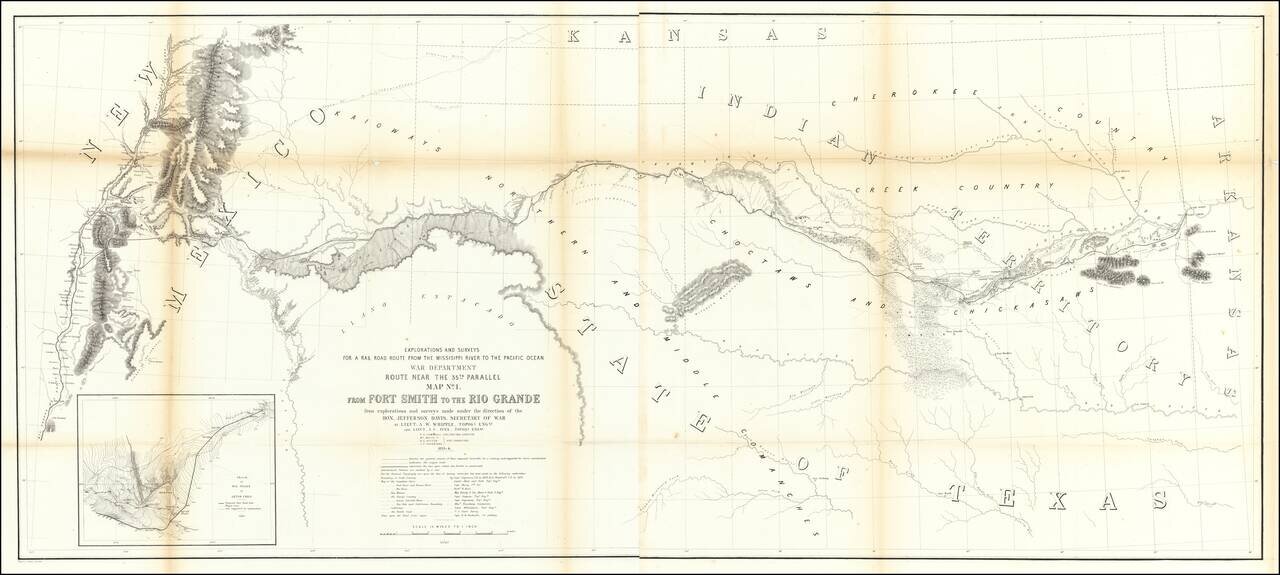
Important early map of the region between Fort Smith Arkansas and the Rio Grande River (Santa Fe, Taos, etc), prepared by the US Pacific Railroad Survey.

The primary cartographic detail is in the Rio Grande Valley of New Mexico and along the Canadian River, tracing the exploration route of this party through Indian Territory and northern Texas, on to the Rio Grande River, just south of Albuquerque.

The map was the product of the work of two of the most important western explorers and surveyors, AW Whipple and JC Ives, who would spend much of their professional careers exploring and mapping the west.

The map identifies a number of source maps that were utilized, including prior maps by

  • Abert & Peck
  • Captain Marcy
  • Richard H. Kern
  • Capt. Simpson
  • Captain Sitgreaves
  • Lt. Wiliamson
  • E.G. Beckwith

Special conditions for students!

If you are a student, write to us in telegram: @antiquemaps and indicate what material you need and for what work you need a map in high detail. We are ready to provide material on special terms. For students only!

Item information:

Year of creation:
Size:
31254x14049 px
Disk:
60.7826MiB
Number of pages:
1
Place:
Washington D.C.
Author:
U.S. Pacific RR Surveys.
$29.99

Related item