Map size in jpg-format: 19.3017MiB
Click to open in high resolution (open in new tab).
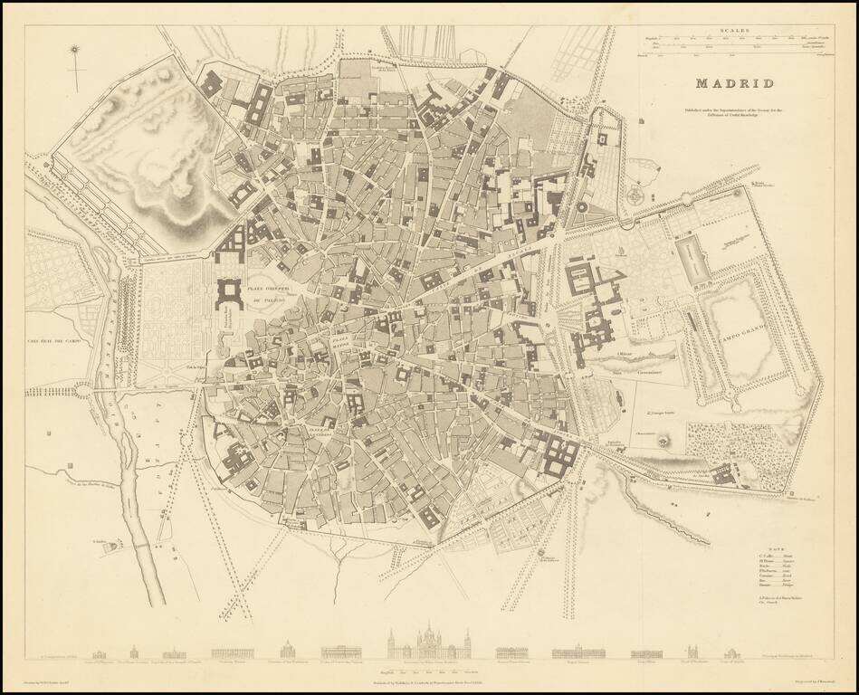
A highly detailed plan of Madrid, with a series of building profiles at the bottom. The map shows bridges, roads, rivers, gates, prados, plazas, streets, buildings, castles, gardens, and more. This is of the best plans of Madrid published in a commercial 19th-century atlas.
The city is still small and contained within its old ramparts. This limits it to mostly the modern Centro and Justicia Districts (constrained by a ring road which follows the ramparts), with the royal palace on the western outskirts. To the east of the city are various gardens, pastures, and fields.
The demographics of the city would soon change when the throne passed from Ferdinand VII to Isabella II. 1833 reforms would make this city capital of the country, and liberal policies would lead to the widening of public spaces and the destruction of some church property. This egalitarian expansion would continue until 1860, when conservative town planning led to segregation along class lines.
The largest and most central building depicted is El Escorial, the residence of the King of Spain, despite it not being located in Madrid but in nearby San Lorenzo. Other buildings portrayed are the Royal Palace, the Convent of the Salesas Reales, and the Church of San Norberto, the last of which is no longer standing.
If you are a student, write to us in telegram: @antiquemaps and indicate what material you need and for what work you need a map in high detail. We are ready to provide material on special terms. For students only!
![(Pro-Spanish Republic Political Broadside) [Lift The Embargo Against The Spanish Republic] President Roosevelt says . . .](/map/small/50218.jpg)

