logo

1892. Lake Front Chicago Illinois From Surveys made under the direction of Captain W.L. Marshall in 1892.

  • Lake Front Chicago Illinois From Surveys made under the direction of Captain W.L. Marshall in 1892.

Lake Front Chicago Illinois From Surveys made under the direction of Captain W.L. Marshall in 1892. information:

Year of creation: 
Resolution size (pixels): 
 15665x10419 px
Disk Size: 
 19.3996MiB
Number of pages: 
 1
Place: 
 Washington, D.C.

Print information. Print size (Width x height in inches):
Printing at 72 dpi 
  217.57 х 144.71
Printing at 150 dpi 
 104.43 х 69.46
Printing at 300 dpi 
 52.22 х 34.73

An example of detailing the file of this map of in a printable high-resolution:

Click to open in high resolution (open in new tab).
Attention! this is just the central piece (central area 960x960 px) of the map file!
This is an example, so that you can see and study the level of detail of a given map. The entire Map will be fully available after payment!

Lake Front Chicago Illinois From Surveys made under the direction of Captain W.L. Marshall in 1892.

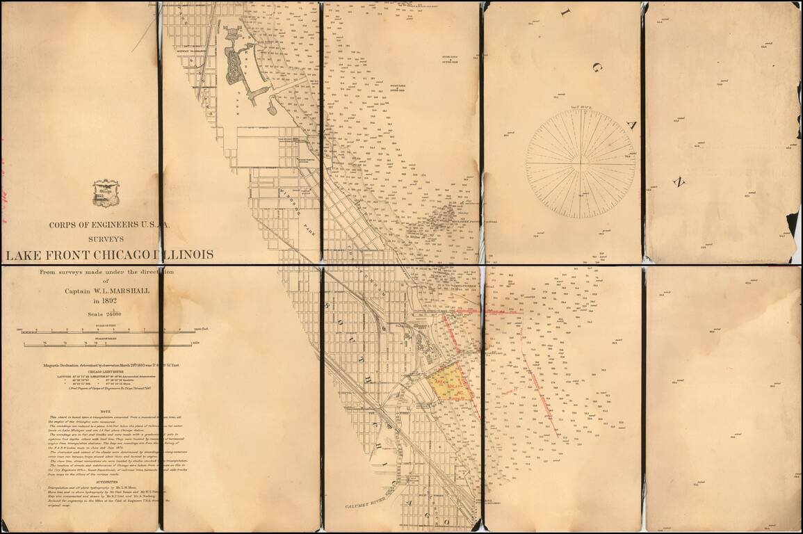
With Manuscript Annotations Showing Proposed Harbor Improvements

Detailed map of part of the City of Chicago, from Jackson Park to the Colehour Yard area, prepared by the United States Corps of Topographical Engineers in 1892.

The map is centered near the lands of the Illinois Steel Company and National Smelting & Refining Co. The U.S.L.S. Station and U.S. Engineers Building are also shown near the mouth of the Calumet River. Further south, the location of the Chicago Ship Building Company is shown.

The map is extra illustrated in Yellow and red, identifying an area in the vicinity of Calumet Harbor, noting:

  • Dock Line Established Jan 25, 1899 By The Secretary of War
  • Breakwater Contracted For
  • Proposed Breakwater

In 1899, the construction of a breakwater to create an artificial harbor at the entrance to the Calumet River was authorized. Starting from a point roughly a half mile north of the river’s entrance, the breakwater, formed of timber cribs capped by concrete, projects east into the lake for about 4,000 feet before bending to the southeast.


Special conditions for students!

If you are a student, write to us in telegram: @antiquemaps and indicate what material you need and for what work you need a map in high detail. We are ready to provide material on special terms. For students only!

Item information:

Year of creation:
Size:
15665x10419 px
Disk:
19.3996MiB
Number of pages:
1
Place:
Washington, D.C.
Author:
U.S. Army Corps of Topographical Engineer.
$14.99

Related item