Map size in jpg-format: 589559B
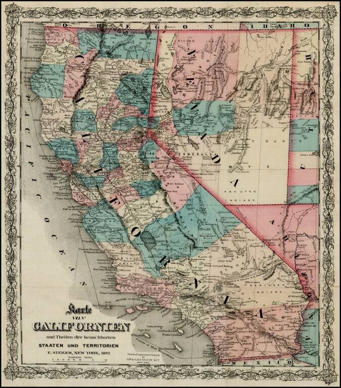
Rare separately issued map of California, published in New York City by Colton.
Includes excellent detail throughout the map, including counties, roads, rivers, lakes, mountains, railroads, stations, gold mines, dry lakes, extinct volcano craters, many curious mining districts in San Bernardino and Tulare Counties and also in Esmerelda County.
Various Emmigrant Roads, the Steamship routes along the coast and a host of other early details are noted. Fredonyet's Trail of 1850 is shown. Copper Mines are shown in LA County and Gold Mines in SD County. Mojave Sink and Camp Cody are listed. Numerous crossings shown on the Colorado River.
One of the most detailed and interesting separately issued maps of California we have seen from this period. We are unsure of the source, which may be a German Emmigrant's Guide.
G. W. & C. B. Colton was a prominent family firm of mapmakers who were leaders in the American map trade in the nineteenth century. The business was founded by Joseph Hutchins Colton (1800-1893) who bought copyrights to existing maps and oversaw their production. By the 1850s, their output had expanded to include original maps, guidebooks, atlases, and railroad maps. Joseph was succeeded by his sons, George Woolworth (1827-1901) and Charles B. Colton (1831-1916). The firm was renamed G. W. & C. B. Colton as a result. George is thought responsible for their best-known work, the General Atlas, originally published under that title in 1857. In 1898, the brothers merged their business and the firm became Colton, Ohman, & Co., which operated until 1901, when August R. Ohman took on the business alone and dropped the Colton name.
If you are a student, write to us in telegram: @antiquemaps and indicate what material you need and for what work you need a map in high detail. We are ready to provide material on special terms. For students only!


