Map size in jpg-format: 7.70922MiB
Click to open in high resolution (open in new tab).
Mississippi Territory !
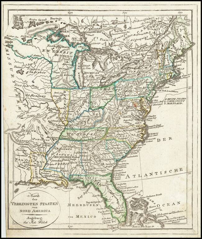
Rare early state of Walch's map of the United States, showing a number of early and transitional territorial configurations. This map vividly illustrates the fluid nature of American territorial boundaries between the Louisiana Purchase and the Adams-Onis Treaty in 1819.
The map pre-dates the establishment of Mississippi Territory, with a massive Georgia extending to the Mississippi River.
Curiously Florida is also shown extending to New Orleans.
The map shows a massive Indiana Territory, pre-dating the delineation of Illinois or Michigan Territories.
Louisiana is shown, as is the former Neu Orleans territory, which briefly existed during the Spanish and French control of the region. Massive Missury Territory.
Excellent detail including forts, Indian Tribes, and other interesting details.
Johann, or Johannes, Walch (1757-1816) was a painter and engraver. He was well-known for painting miniature portraits, having trained in Geneva, Venice, and Rome. Walch published several atlases and sheet maps. As with his atlases, many of Walch’s maps were reprinted after his death.
If you are a student, write to us in telegram: @antiquemaps and indicate what material you need and for what work you need a map in high detail. We are ready to provide material on special terms. For students only!

![[Signed Political Satire Artwork] Vietnam ... Vietnam ... Vietnam ...](/map/small/68726.jpg)
