Map size in jpg-format: 1262010B
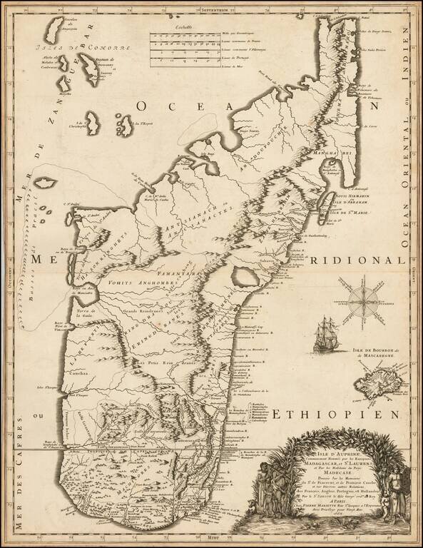
Finely engraved map of Madagascar, published by Pierre Mariette.
The map was perhaps the finest and most up to date of its time, utilized by contemporary explorers.
As noted in The Voyages Made by Sieur Du Bois To The Islands of Dauphine of Madagacar & Bourbon or Mascarenne in the Years 1669 - 70 - 71 & 72 Translated & Edited By Captain Pafield Oliver (Hakluyt Edition, 1897):
I have been advis'd to append to this Narrative a Map of the Isles of Madagascar & of Mascarenne; but as I know that the Geographers of France & of Holland have given many of them at various Times, I have desir'd to see the most considerable; & after having examin'd them with some Exactitude, I have not found any which approach'd more the Truth than that of the Sievr Sanson, of which the following is the Title:-Isle Dauphine, communement nommee tar les Européens, Madagascar, & Saint Laurens, &c. Par le Sieur Sanson le fils, Geographe du Roy, A Paris chez P. Mariette, rue Saint Iacques, 1667. Altho' this Map may be the most exact of all those which I have seen, nevertheless I make mention of some places in my Narrative which are not in this Map.The son of famous French cartographer Nicolas Sanson, Guillaume (1633-1703) carried on his father's work. Like his sire, he was a court geographer to Louis XIV. He often worked in partnership with another prominent cartographer of the time, Hubert Jaillot.
If you are a student, write to us in telegram: @antiquemaps and indicate what material you need and for what work you need a map in high detail. We are ready to provide material on special terms. For students only!

![[Ascension Island] The True Description of the Island of Ascention lyeing under 8 degrees on ye South syde of ye Equinoctiall lyne.](/map/small/69468.jpg)