Map size in jpg-format: 10.2118MiB
Click to open in high resolution (open in new tab).
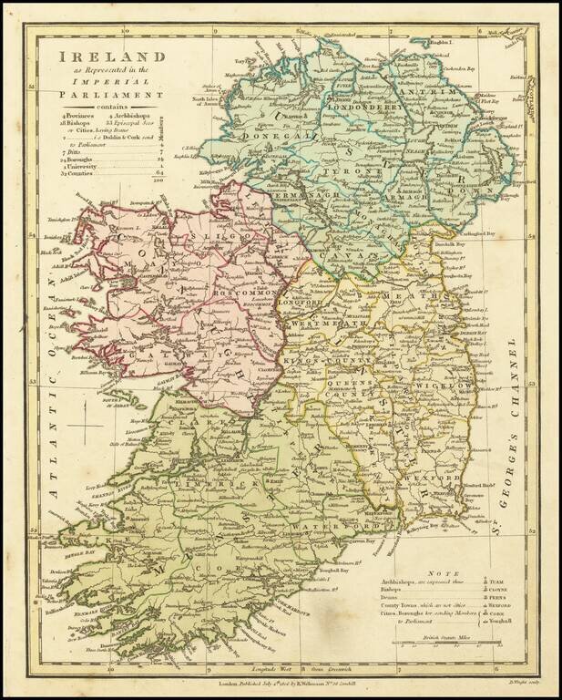
A fascinating map showing the electoral divisions of Ireland shortly after the island began sending MPs to Westminster.
This map shows Ireland divided into its four provinces: Ulster, Leinster, Munster and Connaught and its 32 traditional counties. It also notes the seats of Archbishops, Bishops and Episcopal Sees. The map was issued shortly after the passage of the Union with Ireland Act of 1800, following which Ireland became united with Great Britain to form a single political entity, as opposed to being a distinct entity within the British Empire. The Irish Rebellion of 1798 motivated Whitehall to place Ireland under heal. The last vestiges of Irish autonomy were removed and the Irish Parliament in Dublin was dissolved. Henceforth, Ireland began to send MPs directly to the British Parliament at Westminster.
The table in the upper right explains that the various political entities noted on the map sent a total of 100 MPs to Westminster. The map appeared within Robert Wilkinson's General Atlas of the World, Quarters, Empires, Kingdoms, States &c. with Appropriate Tables (London, 1806).
If you are a student, write to us in telegram: @antiquemaps and indicate what material you need and for what work you need a map in high detail. We are ready to provide material on special terms. For students only!
![Johnson's Ireland [with] Johnson's Scotland](/map/small/71010.jpg)