logo

1680. Insulae Americanae in Oceano Septentrionali ac Regiones Adiacentes, a C. de May usque ad Lineam Aequinoctialem . . .

  • Insulae Americanae in Oceano Septentrionali ac Regiones Adiacentes, a C. de May usque ad Lineam Aequinoctialem . . .

Insulae Americanae in Oceano Septentrionali ac Regiones Adiacentes, a C. de May usque ad Lineam Aequinoctialem . . . information:

Year of creation: 
Resolution size (pixels): 
 14456x12134 px
Disk Size: 
 43.5624MiB
Number of pages: 
 1
Place: 
 Amsterdam
Author: 

Print information. Print size (Width x height in inches):
Printing at 72 dpi 
  200.78 х 168.53
Printing at 150 dpi 
 96.37 х 80.89
Printing at 300 dpi 
 48.19 х 40.45

An example of detailing the file of this map of in a printable high-resolution:

Click to open in high resolution (open in new tab).
Attention! this is just the central piece (central area 960x960 px) of the map file!
This is an example, so that you can see and study the level of detail of a given map. The entire Map will be fully available after payment!

Insulae Americanae in Oceano Septentrionali ac Regiones Adiacentes, a C. de May usque ad Lineam Aequinoctialem . . .

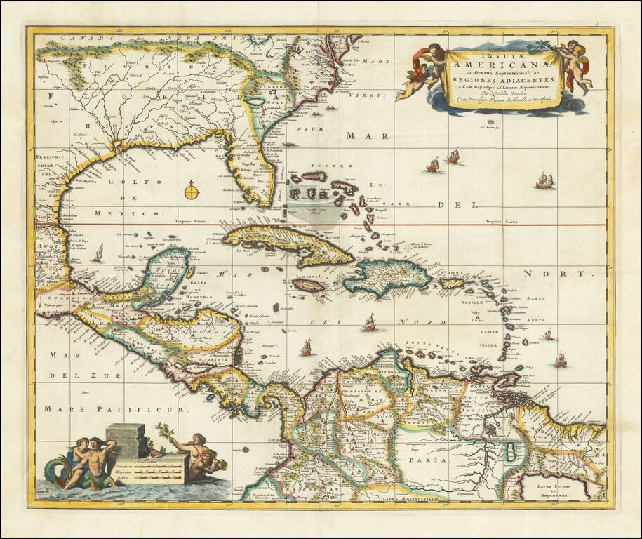
Nice example of Nicholas Visscher's map of the Caribbean, Florida, Southern US, Central America and part of South America.

A number of cartographic myths appear on the map, including the large lake which appears in Georgia, a non-existent mountain range extending from the Piedmonts right across the continent, and the archetypal cartographic myth, El Dorado located on Lacus Parime in Guyana. Interesting early treatment of the Mississippi River Valley, which is far to the west of its proper course and shows little of the French Jesuit information which was to be reported in the following decades.

Excellent detail in the Caribbean. Includes 2 decorative cartouches, and sailing ships.

There are 4 states of the map:

  • 1680 ca: lacking privilege
  • 1682 ca: "Cum Privelegio Ordinum Hollandiae et Westfrisiae"
  • 1708 ca: Grid lines added
  • 1720 ca: Peter Schenk Junior added, cartouches retouched
Lowery 179; Portinaro 82.

Special conditions for students!

If you are a student, write to us in telegram: @antiquemaps and indicate what material you need and for what work you need a map in high detail. We are ready to provide material on special terms. For students only!

Item information:

Year of creation:
Size:
14456x12134 px
Disk:
43.5624MiB
Number of pages:
1
Place:
Amsterdam
Author:
Nicolaes Visscher I.
$14.99

Related item