logo

1831. Il Regno Di Polonia Secondo W.E. Schlieben corretto ed ampliato Da Giuseppe Dembsher

  • Il Regno Di Polonia Secondo W.E. Schlieben corretto ed ampliato Da Giuseppe Dembsher

Il Regno Di Polonia Secondo W.E. Schlieben corretto ed ampliato Da Giuseppe Dembsher information:

Year of creation: 
Resolution size (pixels): 
 4039x5847 px
Disk Size: 
 3.66088MiB
Number of pages: 
 1
Place: 
 Venice
Author: 

Print information. Print size (Width x height in inches):
Printing at 72 dpi 
  56.1 х 81.21
Printing at 150 dpi 
 26.93 х 38.98
Printing at 300 dpi 
 13.46 х 19.49

An example of detailing the file of this map of in a printable high-resolution:

Click to open in high resolution (open in new tab).
Attention! this is just the central piece (central area 960x960 px) of the map file!
This is an example, so that you can see and study the level of detail of a given map. The entire Map will be fully available after payment!

Il Regno Di Polonia Secondo W.E. Schlieben corretto ed ampliato Da Giuseppe Dembsher

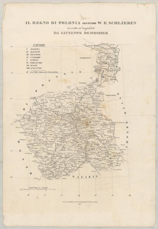
Very rare separately published map of Poland, drawn from W.E. Schlieben's map.

The size is for the full sheet.

The map shows the towns, roads, rivers, lakes and other details in Poland.


Special conditions for students!

If you are a student, write to us in telegram: @antiquemaps and indicate what material you need and for what work you need a map in high detail. We are ready to provide material on special terms. For students only!

Item information:

Year of creation:
Size:
4039x5847 px
Disk:
3.66088MiB
Number of pages:
1
Place:
Venice
Author:
Giuseppe Dembsher.
$14.99

Related item