Map size in jpg-format: 44.0126MiB
Click to open in high resolution (open in new tab).
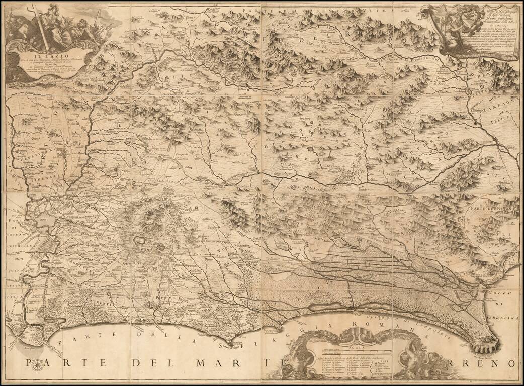
Nice example of Rossi's 4 sheet map of the Lazio region, including Rome, first published in 1693.
The map shows the Lazio territory from Rome to Circeo, with incredible detail. Drawn and engraved by Giacomo Filippo Ameti. The cartouche in the upper left of the first table shows allegories of Tiber and Roma.
After the expansion of Rome, Pope Alexander VII assigned to Freanceso Eschinardi, an Italian mathematician and Philosopher, and a member of the Pontifical Academy of Sciences, the task of overseeing the map Agro-Romano Regions, . The map is largely drawn from the work of Innocenzo Mattei, a papal geographer under Clement X, in 1666, with revisions in the coastal regions.
The map is dedicated to Cardinal Pietro Ottoboni.
Giacomo Giovanni Rossi (1627-1691) was an Italian engraver and printer. He worked in Rome, the heir to an important printing business founded by his father, Giuseppe de Rossi (1570-1639). Giuseppe began the press in 1633 and Giovanni and his brother, Giandomenico (1619-1653) took it over upon his death. The brothers expanded the business and by the mid-seventeenth century it was the best-known printing house in Rome.
For his maps, Giovanni worked with Giacomo Cantelli da Vignola. They produced the Atlas Mercurio Geografico. The first edition is undated, but the second was issued in 1692, a year after Giovanni’s death. The maps were by Cantelli. The firm also published maps based on those of Nicolas Sanson.
Later, the business passed to Lorenzo Filippo (1682-?). By 1738, the firm was known as Calcografia Camerale, then, from 1870 to 1945, as the Regia Calcografica. Today, the firm is still in business and is called Calcografia Nazionale. It operates as a free museum and offers one of the best collections of prints and plates in the world.
If you are a student, write to us in telegram: @antiquemaps and indicate what material you need and for what work you need a map in high detail. We are ready to provide material on special terms. For students only!


