Map size in jpg-format: 20.6267MiB
Click to open in high resolution (open in new tab).

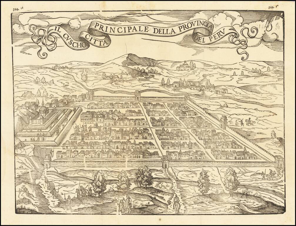
Fine example of this influential and decorative birdseye view of Cusco, from Ramusio's Raccolta di Navigationi et Viaggi., one of the most influential geographical works of the 16th Century.
The view would later be copied by Munster and other 16th Century source.
Ramusio’s Navigationi et Viaggi
Ramusio, a Venetian civil servant, spent decades gathering images, accounts, and sources for a massive collection of travels and voyages. He wanted to update the geographic knowledge of antiquity, which was being challenged by European interactions with the Americas, Africa, and Asia. He especially wanted his work to be useful to mapmakers in updating their representations of the known world.
One of the larger printing projects of the sixteenth century, the collection eventually appeared in three volumes. They were published by Tommaso Giunti in Venice and only in a later edition, in 1563, was the author revealed to be Ramusio. The first volume was published in 1550 and held information about Africa, India, and the East Indies. The second was published in 1559 and discussed Russia, the Middle East, and Central Asia. The third volume, published before the second in 1556, held information about the Americas.
The second volume was delayed because of a large fire in Ramusio’s workshop in 1557; the flames ruined the volume’s woodblocks, forcing the second edition to be published two years later and with no maps. The maps that were included in the other volumes were most likely the work of Giacomo Gastaldi, who tutored Ramusio’s son. While the first volume had three maps and plans, and the second none due to the fire, the third volume had nine maps of the Americas, Africa, and the East Indies.
The work was an important milestone in publishing and each edition was reprinted several times: volume I in 1550, 1554 (with additions), 1563 (with an additional leaf mentioning Ramusio as author), 1588, 1606, and 1613; volume II in 1559, 1574 (with additions), 1583 (further additions), and 1606; and volume III in 1556, 1565 and 1606 (with additions). Only once, in 1606, were all three volumes reprinted in the same year.
Giovanni Battista Ramusio (1485-1557) was an Italian geographer who worked within the Venetian Empire. His father had been a magistrate and he himself served as a civil servant to Venice. He served throughout Europe, allowing him to build up a network of informants and a collection of travel materials. He compiled this information into his enduring masterpiece, Navigationi et Viaggi, in 1550 (first volume) and 1556 (third volume). The second volume appeared after his death in 1559, as the original manuscript had been destroyed by a fire.
If you are a student, write to us in telegram: @antiquemaps and indicate what material you need and for what work you need a map in high detail. We are ready to provide material on special terms. For students only!
![[Straits of Le Maire, Nova Guinea, South Pacific]](/map/small/61345op.jpg)