Map size in jpg-format: 9060400B
Click to open in high resolution (open in new tab).
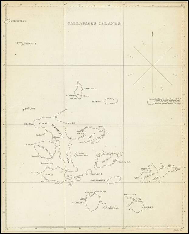
The First American Map of the Galapagos Islands
Scarce early 19th Century map showing the Galapagos Islands in detail.
An unnamed island (the modern Genovesa) is shown with a note that it "is situated agreably to the report of several Whalemen and corresponds to the position in which it was seen by Lieunt. Downes U.S.N. 1813."
The map appeared in David Porter's Journal of a Cruise made to the Pacific Ocean, by Captain David Porter, in the United States Frigate ESSEX, in the years 1812, 1813, and 1814. Containing Descriptions of the Cape de Verd Islands, Coasts of Brazil, Patagonia, Chili, and Peru, and of the Gallapagos Islands; also, A full Account of the Washington Groupe [sic] of Islands, the Manners, Customs, and Dress of the Inhabitants, &c. &c. , first published in Philadelphia in 1822.
Porter sailed for the United State Navy at the beginning of the War of 1812, with orders to cruise against British shipping in the Atlantic. He continued south, rounding Cape Horn and attacking British whalers in the South Atlantic and the Galapagos, before landing in the Marquesas and annexing the islands to the United States. His was captured by the British off the Chilean Coast in 1814. Returning to a hero's welcome in the U.S.
If you are a student, write to us in telegram: @antiquemaps and indicate what material you need and for what work you need a map in high detail. We are ready to provide material on special terms. For students only!
![[Straits of Le Maire, Nova Guinea, South Pacific]](/map/small/61345op.jpg)