Map size in jpg-format: 17.8852MiB
Click to open in high resolution (open in new tab).
Building the First Breakwater and Artificial Port of Its Kind in America.
Rare engraved map by Guillaume-Tell Poussin, related to the construction of the Delaware Breakwater in the Delaware Bay in the 1820s.
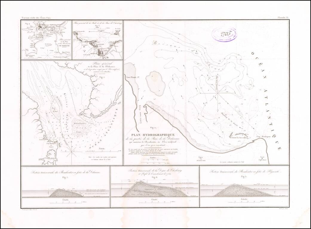
The sheet features a map of the mouth of Delaware Bay as figure 1, titled "Plan general de la Baie de la Delaware et de la position occupee par le Port artificiel, construie a sou embouchure." Figure 2 shows the construction of an artificial bay at Cape Henlopen, titled "Plan Hydrographique de la partie de la Baie de la Delaware qui avoisine le Breakwater ou Port artificiel. que l'on y a construit."
The sheet also has maps of Plymouth and Cherbourg, and diagrams of their breakwaters, to illustrate how the concept had already been put into action elsewhere.
A fascinating document of early civil engineering in the United States.
The map appeared in the Travaux d'ameliorations interieures projetes ou executes par le Gouvernement General des Etats-Unis d'Amerique, de 1824 a 1831; par Guillaume-Tell Poussin. Poussin's work was a general synthesis of scientific projects in the United States, including the Florida Canal project, undertaken after he returned from America in 1832.
Rarity
The map is very rare on the market. This is the first example we have ever seen and we can find no examples of the book appearing on the market with the map in a dealer catalog or auction record.
If you are a student, write to us in telegram: @antiquemaps and indicate what material you need and for what work you need a map in high detail. We are ready to provide material on special terms. For students only!
![(American Revolution) [Manuscript Map of New York City and Northern New Jersey]](/map/small/69609.jpg)