logo

1844. (Estonia) Generalcharte von Ehstland, in 2 Blättern mit Unterstützung des Vereins der Merino zucht zu Orrenhoff, herausgegeben von I. H. Schmidt

  • (Estonia) Generalcharte von Ehstland, in 2 Blättern mit Unterstützung des Vereins der Merino zucht zu Orrenhoff, herausgegeben von I. H. Schmidt
  • (Estonia) Generalcharte von Ehstland, in 2 Blättern mit Unterstützung des Vereins der Merino zucht zu Orrenhoff, herausgegeben von I. H. Schmidt

(Estonia) Generalcharte von Ehstland, in 2 Blättern mit Unterstützung des Vereins der Merino zucht zu Orrenhoff, herausgegeben von I. H. Schmidt information:

Year of creation: 
Resolution size (pixels): 
 35888x15693 px
Disk Size: 
 167.635MiB
Number of pages: 
 2
Place: 
 n.p. [Riga]

Print information. Print size (Width x height in inches):
Printing at 72 dpi 
  498.44 х 217.96
Printing at 150 dpi 
 239.25 х 104.62
Printing at 300 dpi 
 119.63 х 52.31

An example of detailing the file of this map of in a printable high-resolution:

Click to open in high resolution (open in new tab).
Attention! this is just the central piece (central area 960x960 px) of the map file!
This is an example, so that you can see and study the level of detail of a given map. The entire Map will be fully available after payment!

(Estonia) Generalcharte von Ehstland, in 2 Blättern mit Unterstützung des Vereins der Merino zucht zu Orrenhoff, herausgegeben von I. H. Schmidt

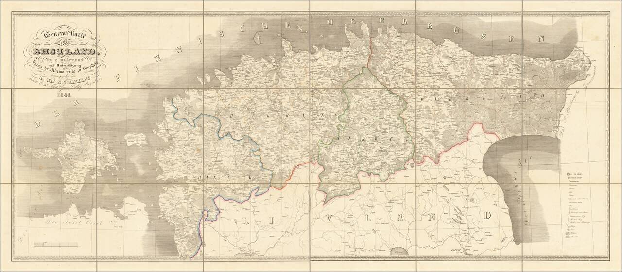
Interesting and scarce map of old Estonia (the old Duchy of Estonia, or Ehstland in German), stretching from the St. Petersburg Government in the east to Hiiumaa Island in the west. To the south of the map is "Livland", which is today part of modern Estonia. This differentiation dating back to the historic borders between Swedish Livonia and Swedish Estonia and earlier incarnations.

The map was published in Riga for Baltic Germans who resided in Estonia when it was part of the Russian Empire.

Talin is labeled "Reval" on the map, as was the convention at the time.


Special conditions for students!

If you are a student, write to us in telegram: @antiquemaps and indicate what material you need and for what work you need a map in high detail. We are ready to provide material on special terms. For students only!

Item information:

Year of creation:
Size:
35888x15693 px
Disk:
167.635MiB
Number of pages:
2
Place:
n.p. [Riga]
Author:
Johan Heinrich Schmidt.
$29.99

Related item