Map size in jpg-format: 57.6731MiB
Click to open in high resolution (open in new tab).

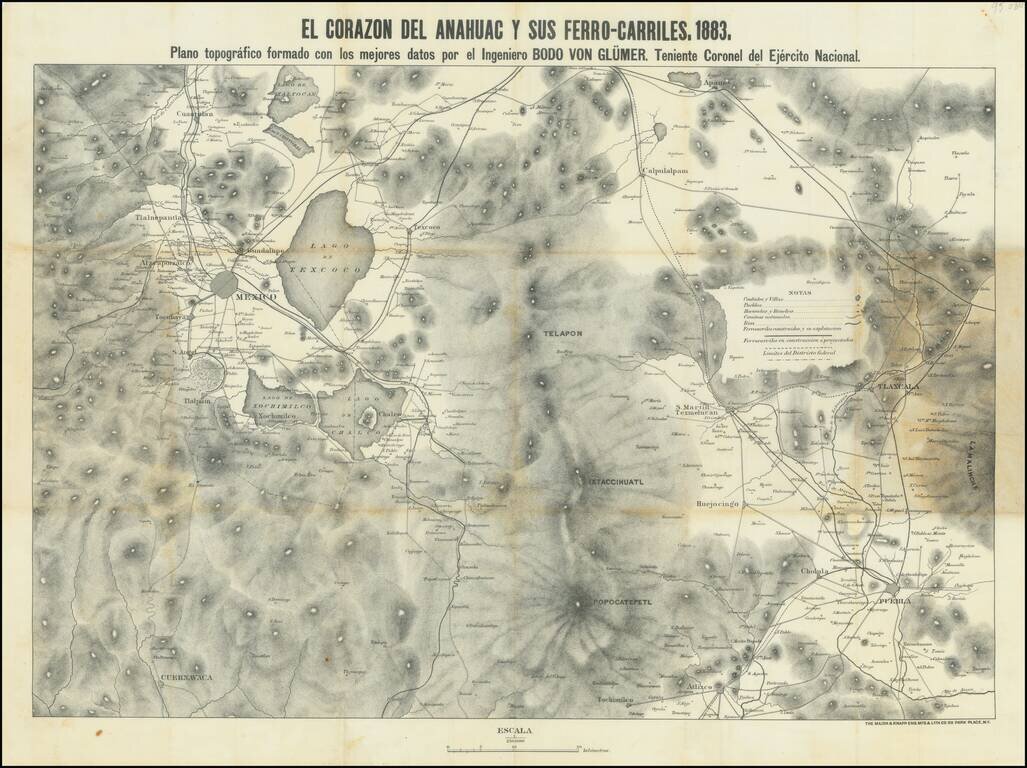
This is a map showing the region around Mexico City, focusing on the railroads of the area. Topography, cities, towns, rivers, and other roads are also shown. The title refers to the Nahuatl name for the Aztec homeland.
Mexico City is visible in the west of the map, with the extent of the Distrito Federal outlined. The city proper is still small, and Tacubaya, Atzacapotzalco, and Texcoco have not yet been engulfed by the metropolis. Most of the railway lines in the area spring from this city, with Puebla acting as another regional hub. The proposed railway lines shown would act to decentralize the area, allowing for areas outside of Mexico City to grow. The map shows topography in shaded relief and labels the many mountains and volcanoes around the region.
The Lago de Texcoco is still visible, as are several other small lakes in the vicinity of Mexico City. While Tenochtitlan, the forbearer to Mexico City, was originally in the middle of a vast lake, drainage efforts by the Spanish and Mexican governments had already greatly reduced the extent of the lake by 1883. All that remains of this former lake today are small ponds and salt marshes, mostly in the northeast of the city.
The construction of Mexican railways had only commenced a decade prior to the creation of this map in 1873. President Porfirio Díaz, elected in 1877, heavily encouraged development in the area around Mexico City, notably with the founding of new railway lines. He attempted to attract European and American investment through generous concessions, and by the time this plan was made, many railway lines were running, with even more planned or in construction. These were very successful, and the Mexican railway system was nationalized in 1909.
This map was published at the end of the González Interregnum, the period between 1880 and 1884 when General Manuel González held the presidency after Porfirio Díaz had stepped down. The period was marked by increasing openness to investment by U.S. nationals and an attempt by the Mexican government to make the country seem like a safe and attractive place to invest. This map clearly means to advance that cause by displaying Mexico's developing railroad infrastructure.
Bodo Von Glumer was a German baron and colonel in the Mexican army, who had become the second husband of the New York socialite Frances Bartlett a year before contributing to this map. This example is dedicated to Antogenes Carrasco. An 1882 telegram from the Minster for Development identifies him as the "Jefe Politico del Distrito" [the political boss for Mexico City] and applauds him for his work at the inauguration of a new railway line. While what exactly his present position entails is uncertain, he would be the director of the city of Puebla by 1902. This map was likely a gift relating to the opening of a new route to commemorate his work in completing it.
We are unable to find other examples of this map, although the BNF's 1885 catalog records a map with the same subject by Glumer.
If you are a student, write to us in telegram: @antiquemaps and indicate what material you need and for what work you need a map in high detail. We are ready to provide material on special terms. For students only!


![Map of Mexico, Central America, and the West Indies [Insets of Bermuda, Sandwich Islands, Jamaica and Panama Railroad]](/map/small/69133.jpg)