Map size in jpg-format: 36.7857MiB
Click to open in high resolution (open in new tab).
Rare Separately Published Map from Kindermann's Important Atlas of Inner Austria
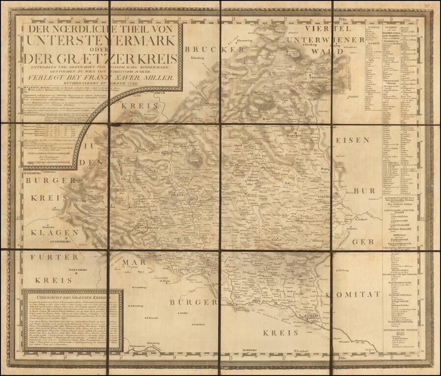
Rare late 18th Century map of the Graz region in Southwestern Austraia, which was one of 12 maps, typically referred to as the Atlas von Inner Osterreich (Atlas of Inner Austria).
The Atlas von Inner Osterreich is considered to be one of the most important cartographic works of the 18th Century for Austria.
The Atlas consisted of a 12 map series (key sheet plus 11 maps) published for the first time between 1789 and 1797 by Franz Xaver Miller in Graz. The maps were drawn from the work of Joseph Karl Kindermann (1744-1801) and was engraved by Christoph Junker in Vienna.
According to Dörflinger, the Atlas Kindermanns und Millers is the most important regional group of maps from the second half of the 18th century in Austria (Dörflinger 1984, p. 110), along with Peter Anichs and Blasius Huebers Atlas Tyrolensis (1774). Joseph Karl Kindermann
Joseph Karl Kindermann was born in Austria, and began his mapmaking career in 1768 working for the Dutch East India Company in South Africa as secretary of the governor J. van Plettenberg (from 1768). After his return to Europe, Kindermann continued to work in the field of geography and cartography. The Atlas von Inner Osterreich is a loose map collection without its own title page. Only the dedication copy to Emperor Franz II in the Austrian National Library (ÖNB, FKB 280-11) includes a hand-written title page, provides information about the publisher, Franz Xaver Miller: "Atlas of Inner Austria. At the expense of Franz Xaver Miller, described as a "bürgerlichen Buchhändlers zu Graetz," as his contribution to the flowering arts of the Fatherland, and edited in 1797. "(Dörflinger 1995, p. 63). The publisher Franz Xaver Miller was well connected in official circles, which gave Kindermann access to source information for the preparation of the maps.
The quality off the Atlas of Inner Austria is also confirmed by an encounter between Kindermann and Napoleon Bonaparte. Napoleon sent for Kindermann in 1797, since he wanted to get to know the man whose maps has so dramatically aided Napoleon in his Austrian campaign. In this conversation, Bonaparte was shocked to learn that "these maps were only the fruit of a private enterprise," that is, compiled without official or unofficial government funding or assistance. Kindermann largely withdrew from public life until he was summoned to Vienna in the spring of 1801 to serve as chief editor for the "Atlas of the Austrian Empire" (Austrian National Atlas, 1805).
Rarity
The map is very rare on the market.
If you are a student, write to us in telegram: @antiquemaps and indicate what material you need and for what work you need a map in high detail. We are ready to provide material on special terms. For students only!