Map size in jpg-format: 81.3255MiB
Click to open in high resolution (open in new tab).
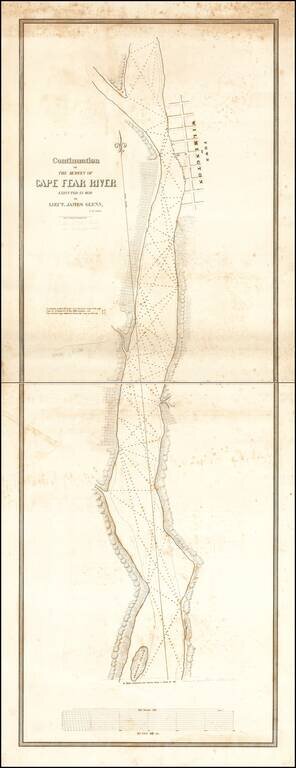
Rare 2-sheet map of a section of the Cape Fear River, prepared under the direction of James Glynn in 1839, as part of the US Navy's search for a suitable port for the establishment of a Southern Navy Yard and printed by P. Haas, Lithy., Washington D.C.
The area covered extends from Graham's Island to Wilmington.
In 1839, the United States Navy commissioned a survey of 4 southern harbors, for the purpose of establishing a Southern Navy Yard. James Glynn (1800-1871), who would later distinguish himself as the leader of negotiations with Japan during their "close country" period, led the expedition, which would ultimately include the charting of Beaufort, Wilmington (Cape Fear River), Sapelo (Georgia) and Doboy (Georgia) as possible locations. Among the officers on the expedition was Matthew Fontaine Maury.
The survey of Cape Fear resulted in the creation of several highly detailed charts of the River and Harbor, including the chart offered here (in 4 sheets), a chart of the Cape Fear River (92 x 21 inches) and a Continuation Chart of the Survey of the Cape Fear River. The resulting charts, along with others the areas surveyed around Beaufort, were apparently issued in a bound portfolio in 1843, although the present example of the map is signed by its makers as having been executed in December 1839. The area shown in this map includes Smithville (now South Port), the future Fort Fisher and the area at the south end of the modern Military Ocean Terminal-Sunny Point.
The survey expedition was led by Lieutenant James Glynn in command of two ships, the Experiment and the Engineer. A fascinating side note for the expedition was the involvement of Mathew Fontaine Maury. Maury would go on to become a leading scientific figure and a commander in the CSA Navy, serving as the Confederacy Chief of Sea Coast, River and Harbor Defenses. Following the Civil War, Maury would go on to achieve worldwide acclaim as an astronomer, historian, oceanographer, meteorologist, cartographer, author, geologist, and educator. He was nicknamed Pathfinder of the Seas and Father of modern Oceanography and Naval Meteorology, and later, Scientist of the Seas, due to the publication of his extensive works in his books, especially Physical Geography of the Sea 1855, the first extensive and comprehensive book on oceanography to be published. Maury made many important new contributions to charting winds and ocean currents, including pathways for ships at sea.
Following his survey of harbors of Beaufort and Wilmington and the inlets of Sapelo and Doboy, Maury was detached from the Engineer at Norfolk, first travelling home to Fredericksburg and then on to visit his Parents in Tennessee. It was on his trip back to the ship after leaving Tennessee that Maury was injured in a Stage Coach accident near Somerset, Ohio, which effectively ended his career at sea. It was during his recovery that he wrote a number of important works, including his advocacy for a formal school for naval training, one of most influential works leading to the establishment of the United States Naval Academy (although Maury suggested Memphis, Tennessee for the academy location). As one commentator noted, Maury's misfortune on the journey home from Tennessee may have launched one of the most distinguished scientific careers of the 19th Century.
Rarity
The chart is of the utmost rarity, with only the examples in the Library of Congress (bound in folio of maps) and separate examples at the State Library of Massachusetts, University of North Carolina and Providence Athenaeum.
If you are a student, write to us in telegram: @antiquemaps and indicate what material you need and for what work you need a map in high detail. We are ready to provide material on special terms. For students only!


![[The First Maps in a la poupée Printed Color] Cartes en Couleur des Lieux Sujets aux tremblements de Terre Dans toutes les parties du Monde Selon le Sisteme de l’impulsion Solaire](/map/small/52293op.jpg)