Map size in jpg-format: 11.3869MiB
Click to open in high resolution (open in new tab).
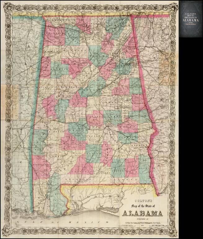
Fine example of this early edition of Colton's large format pocket map of Alabama.
A large scale and highly detailed map, drawn on a scale of two miles to the inch. Shows roads, railroad lines, cities and towns, rivers, lakes, and mountain ranges. Each county is in full, beautiful and original hand color, with decorative printed border.
The map pre-dates the formation of Colbert County in January 1870.
The map was apparently first issued in 1868. We locate no examples of the 1870 edition of the map in OCLC.
The map is rare on the market, especially this early state. The map is not listed in Phillips. We locate only an example of the 1883 edition offered at auction in 2012 and now offered for sale by the Old Print Shop (as of January 2014).
G. W. & C. B. Colton was a prominent family firm of mapmakers who were leaders in the American map trade in the nineteenth century. The business was founded by Joseph Hutchins Colton (1800-1893) who bought copyrights to existing maps and oversaw their production. By the 1850s, their output had expanded to include original maps, guidebooks, atlases, and railroad maps. Joseph was succeeded by his sons, George Woolworth (1827-1901) and Charles B. Colton (1831-1916). The firm was renamed G. W. & C. B. Colton as a result. George is thought responsible for their best-known work, the General Atlas, originally published under that title in 1857. In 1898, the brothers merged their business and the firm became Colton, Ohman, & Co., which operated until 1901, when August R. Ohman took on the business alone and dropped the Colton name.
If you are a student, write to us in telegram: @antiquemaps and indicate what material you need and for what work you need a map in high detail. We are ready to provide material on special terms. For students only!
![The Coast of West Florida and Louisiana . . . [with] The Peninsula and Gulf of Florida or Channel of Bahama with the Bahama Islands . . .](/map/small/38977.jpg)
![The Coast of West Florida and Louisiana . . . [with] The Peninsula and Gulf of Florida or Channel of Bahama with the Bahama Islands . . .](/map/small/66344.jpg)
