logo

1901. City of Denver, Colorado.

  • City of Denver, Colorado.
  • City of Denver, Colorado.

City of Denver, Colorado. information:

Year of creation: 
Resolution size (pixels): 
 7061x7156 px
Disk Size: 
 14.0291MiB
Number of pages: 
 2
Place: 
 Denver
Author: 

Print information. Print size (Width x height in inches):
Printing at 72 dpi 
  98.07 х 99.39
Printing at 150 dpi 
 47.07 х 47.71
Printing at 300 dpi 
 23.54 х 23.85

An example of detailing the file of this map of in a printable high-resolution:

Click to open in high resolution (open in new tab).
Attention! this is just the central piece (central area 960x960 px) of the map file!
This is an example, so that you can see and study the level of detail of a given map. The entire Map will be fully available after payment!

City of Denver, Colorado.

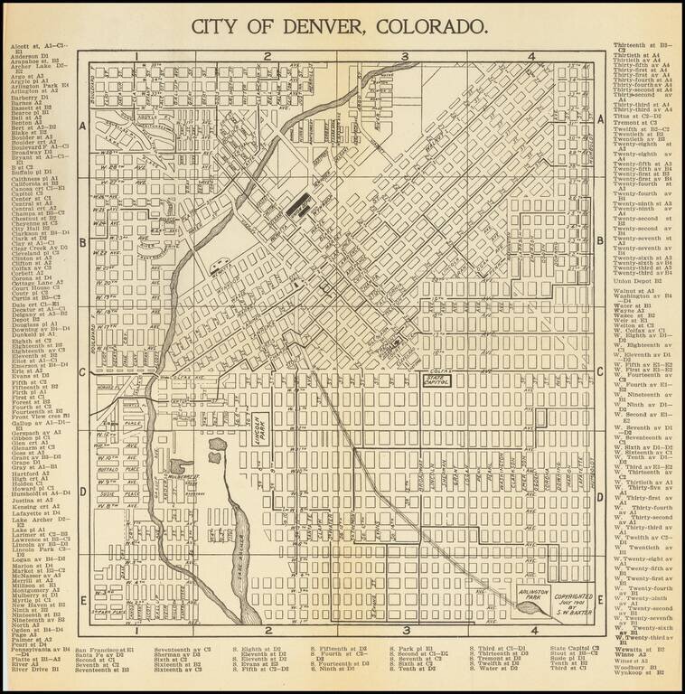
Antique map of Denver, first published in 1901 by S.W. Baxter, and then republished by C.N. Hoover, again in Denver, in 1905.

The map extends to Arlington Park in the southeast and the present-day Potter Highlands Historic District in the northwest.

Many street names are listed on the map itself, and those that could not be fit in the image are included around the margins.


Special conditions for students!

If you are a student, write to us in telegram: @antiquemaps and indicate what material you need and for what work you need a map in high detail. We are ready to provide material on special terms. For students only!

Item information:

Year of creation:
Size:
7061x7156 px
Disk:
14.0291MiB
Number of pages:
2
Place:
Denver
Author:
S.W. Baxter. C.N. Hoover.
$14.99

Related item