logo

1817. Charte von Den Vereinigten Staaten von Nord-America nebst Louisiana…1805 und Florida . . .1805 und nach den Enteckungen der Hrn. Lewis, Clarke und Pike . . . Septbr 1812, unde nach der neuesten Staateneintheinlung begranzt im J. 1817 . . .

  • Charte von Den Vereinigten Staaten von Nord-America nebst Louisiana…1805 und Florida . . .1805 und nach den Enteckungen der Hrn. Lewis, Clarke und Pike . . . Septbr 1812, unde nach der neuesten Staateneintheinlung begranzt im J. 1817 . . .

Charte von Den Vereinigten Staaten von Nord-America nebst Louisiana…1805 und Florida . . .1805 und nach den Enteckungen der Hrn. Lewis, Clarke und Pike . . . Septbr 1812, unde nach der neuesten Staateneintheinlung begranzt im J. 1817 . . . information:

Year of creation: 
Resolution size (pixels): 
 16690x11648 px
Disk Size: 
 56.4676MiB
Number of pages: 
 1
Place: 
 Weimar

Print information. Print size (Width x height in inches):
Printing at 72 dpi 
  231.81 х 161.78
Printing at 150 dpi 
 111.27 х 77.65
Printing at 300 dpi 
 55.63 х 38.83

An example of detailing the file of this map of in a printable high-resolution:

Click to open in high resolution (open in new tab).
Attention! this is just the central piece (central area 960x960 px) of the map file!
This is an example, so that you can see and study the level of detail of a given map. The entire Map will be fully available after payment!

Charte von Den Vereinigten Staaten von Nord-America nebst Louisiana…1805 und Florida . . .1805 und nach den Enteckungen der Hrn. Lewis, Clarke und Pike . . . Septbr 1812, unde nach der neuesten Staateneintheinlung begranzt im J. 1817 . . .

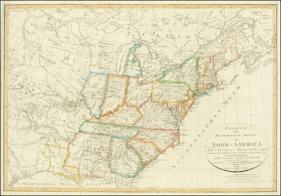
With an unusual appearance of "Neu Orleans" Territory.

Rare late state of Gussefeld's map of the United States, published in the same year as the Louisiana Purchase and highlighting Jefferson's United States on the eve of the expeditions of Lewis & Clark, Zebulon Pike, etc.

Following the Louisiana Purchase in 1805, there was a tremendous push to chart and explore the new American West. Gussefeld's map is illustrative of the extent of contemporary knowledge of the area purchased by Jefferson in 1803, including conjectural mountain ranges in the regions north and south of the Missouri River, scattered Indian Tribes and lots of conjecture.

The map depicts a single Mississippi Territory, 2 years prior to the creation of the State of Alabama. The map also provides an early depiction of Indiana (1 year after statehood) and Illinois Territory (1 year before statehood). New Orleans Territory is still shown (5 years after Louisiana Statehood).

The present map is a modified version of an early map of Gussefeld and one of the earliest to depict the results of Lewis & Clark and Pike's discoveries, which were first reported on the 1812 edition of the map.


Special conditions for students!

If you are a student, write to us in telegram: @antiquemaps and indicate what material you need and for what work you need a map in high detail. We are ready to provide material on special terms. For students only!

Item information:

Year of creation:
Size:
16690x11648 px
Disk:
56.4676MiB
Number of pages:
1
Place:
Weimar
Author:
Franz Ludwig Gussefeld.
$14.99

Related item