logo

1806. Charte von America nach den neuesten Berichten und Entdeckungen entworfen . . . 1806

  • Charte von America nach den neuesten Berichten und Entdeckungen entworfen . . . 1806

Charte von America nach den neuesten Berichten und Entdeckungen entworfen . . . 1806 information:

Year of creation: 
Resolution size (pixels): 
 8462x11063 px
Disk Size: 
 18.2406MiB
Number of pages: 
 1
Place: 
 Weimar

Print information. Print size (Width x height in inches):
Printing at 72 dpi 
  117.53 х 153.65
Printing at 150 dpi 
 56.41 х 73.75
Printing at 300 dpi 
 28.21 х 36.88

An example of detailing the file of this map of in a printable high-resolution:

Click to open in high resolution (open in new tab).
Attention! this is just the central piece (central area 960x960 px) of the map file!
This is an example, so that you can see and study the level of detail of a given map. The entire Map will be fully available after payment!

Charte von America nach den neuesten Berichten und Entdeckungen entworfen . . . 1806

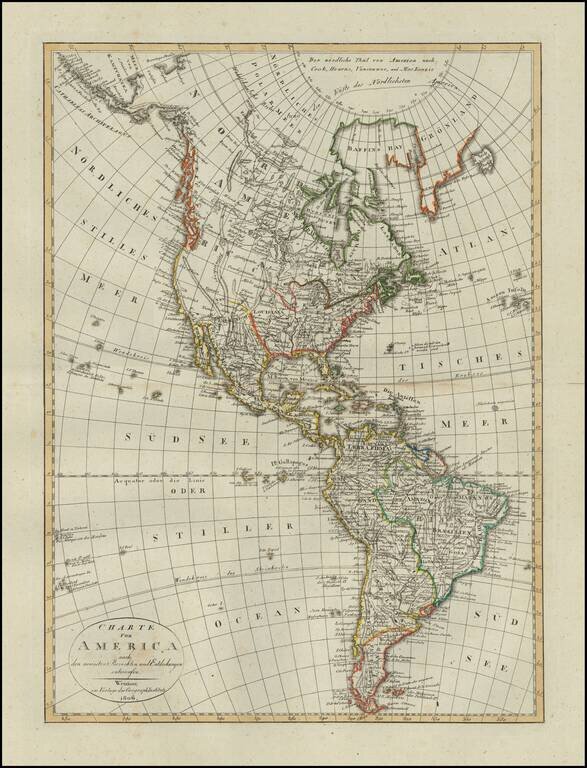
Scarce map of America, published in Weimar in 1806.

The western part of North America is still relatively unknown, pre-dating the reports of Lewis & Clark and other western explorers.

The map shows a very speculative Northwest Passage with a tentative coastline and an incomplete Alaskan Coastline.

A scarce map -- this is the first example we have seen.


Special conditions for students!

If you are a student, write to us in telegram: @antiquemaps and indicate what material you need and for what work you need a map in high detail. We are ready to provide material on special terms. For students only!

Item information:

Year of creation:
Size:
8462x11063 px
Disk:
18.2406MiB
Number of pages:
1
Place:
Weimar
Author:
Weimar Geographische Institut.
$14.99

Related item