Map size in jpg-format: 55.4493MiB
Click to open in high resolution (open in new tab).
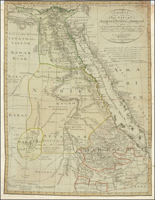
A detailed chart of Egypt, Sudan, and Ethiopia focused on the course of the Nile. Extensive detail is shown, with the many towns along the Nile, Red Sea, and other areas all labeled. Trade routes are shown through the desert and the mountain ranges of Ethiopia and coastal Egypt are shown in detail. Geopolitical boundaries are shown between Egypt, Nubia, Darfur, and "Habesch" (Ethiopia). Franz Ludwig Gussefeld was one of the leading German mapmakers of the late 18th century.
This map was published at the start of modern Egyptology. The Rosetta Stone had been unearthed half a decade prior to the publication of the map and the Greek script translated one year prior. Curiosity was growing in France, Germany, and England as to the little-understood classical culture, and the translation of the hieroglyphs on the stone in 1822 would allow for greater insights. Until then, visiting the statues, monuments, and pyramids left behind would be the only way to study Egyptian history, for which maps like these were invaluable. This present map would have been particularly useful to this budding field of study as it presents a very modern and scientific approach in the mapping of the region, avoiding the speculative information included in most prior 18th century maps.
The Nile is depicted with surprising accuracy, at least until the fourth cataract. The large bend around the area of the 5th cataract is flattened, though the Atbara branch is shown in a correct position. The many branches of the Blue and White Niles are shown, though not always accurately. No lakes, Ptolemaic or real, are shown at the headwaters of the White Nile.
One interesting structure to note in the Atbara is labeled "vorzeiten Astapus." The river fans out here over a large area of desert, something that satellite no longer show, but which the geomorphology suggests could have been a past possibility. As such, the map may preserve important details on how the Nile used to flow. This idea of past flow of the Nile and water through the desert is part of the cutting edge of archeology today. Classical trade routes and settlements would have followed sources of water through the desert, but many factors in the area mean that the locations of water sources vary over human timescales. As such, using geomorphological studies as well as historical sources can provide clues as to where to conduct archeological digs.
The map provides many other fascinating details about the regions, both to experts and lay observes. All the great cities of modern Egypt are labeled, including Luxor, Cairo, Alexandria, and Jeddah. The Red Sea is shown in full, though of course without the Suez Canal. In all, this makes for a very attractive and interesting map of northeastern Africa.
If you are a student, write to us in telegram: @antiquemaps and indicate what material you need and for what work you need a map in high detail. We are ready to provide material on special terms. For students only!
![[Arabian Peninsula, Red Sea, Nile River and Gulf of Aden] L'Afrique . . . 1740](/map/small/59382.jpg)
![Turcici Imperii Imago [shows Cyprus]](/map/small/68676.jpg)