Map size in jpg-format: 16.65MiB
Click to open in high resolution (open in new tab).
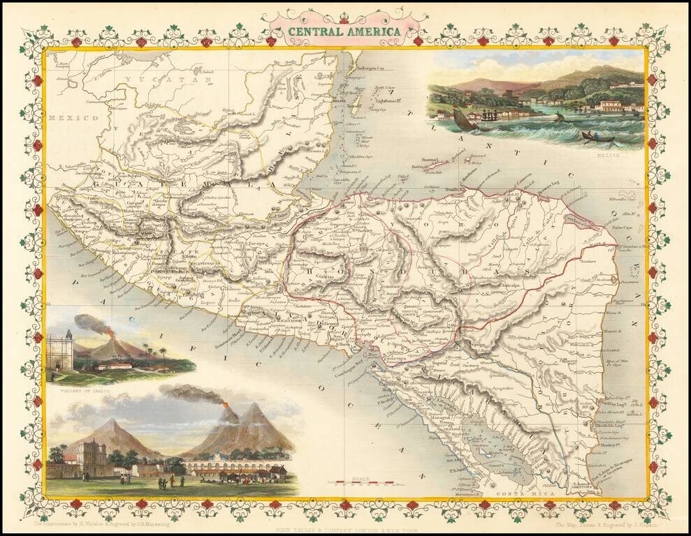
Striking full color example of this wonderful decorative map of Central America, including Guatemala, Honduras, El Salvador, Nicaragua and "Mosquito Territory."
In the body of the map is outline color by country. The map features vignettes of Volcano of Isalco, Great Square of Antigua in Guatamala and Belise, all in remarkable color. Engraved for R. Montgomery Martin's Illustrated Atlas and Modern History of the World, one of the last great decorative atlases of the 19th Century. As noted at the bottom, "The Illustrations by A. Fussell & Engraved by J.B. Allen." and "The Map Drawn & Engraved by J. Rapkin."
John Tallis was one the most popular cartographers of the 19th Century and one of the last great decorative map makers. Tallis was renowned for the very accurate and visually attractive maps and views of all world areas during the Victorian Age. His maps are prized for the wonderful vignettes of indigenous scenes, people, etc. His star engraver and map maker was John Rapkin. During the mid 19th Century many books of travel and exploration were published by Tallis, using the extraordinary artistic and engraving skills of Rapkin. In 1851 Tallis published his famous Illustrated Atlas.
John Tallis (1817-1876) was a British map publisher. Born in the Midlands, Tallis came to London in the 1840s. Tallis began his London career with a series of remarkable London street views. He began a partnership with a Frederick Tallis, possibly his brother, but their collaboration ended in 1849. For the Great Exhibition of 1851, Tallis published the Illustrated World Atlas, one of the last series of decorative world maps ever produced. The maps were engraved by John Rapkin, a skilled artisan. The maps were later reissued by the London Printing & Publishing Company, who left the Tallis imprint intact, thus ensuring his enduring fame. In 1858, he began publication of the popular Illustrated News of the World and National Portrait Gallery of Eminent Personages, selling it in 1861 (it ceased publication in 1863).
If you are a student, write to us in telegram: @antiquemaps and indicate what material you need and for what work you need a map in high detail. We are ready to provide material on special terms. For students only!

![[Blaeu Atlas of America] America, Quae Est Geographiae Blavianae Pars Quinta Liber Unus Volumen Undecimum](/map/small/66852.jpg)
