Map size in jpg-format: 42.7157MiB
Click to open in high resolution (open in new tab).
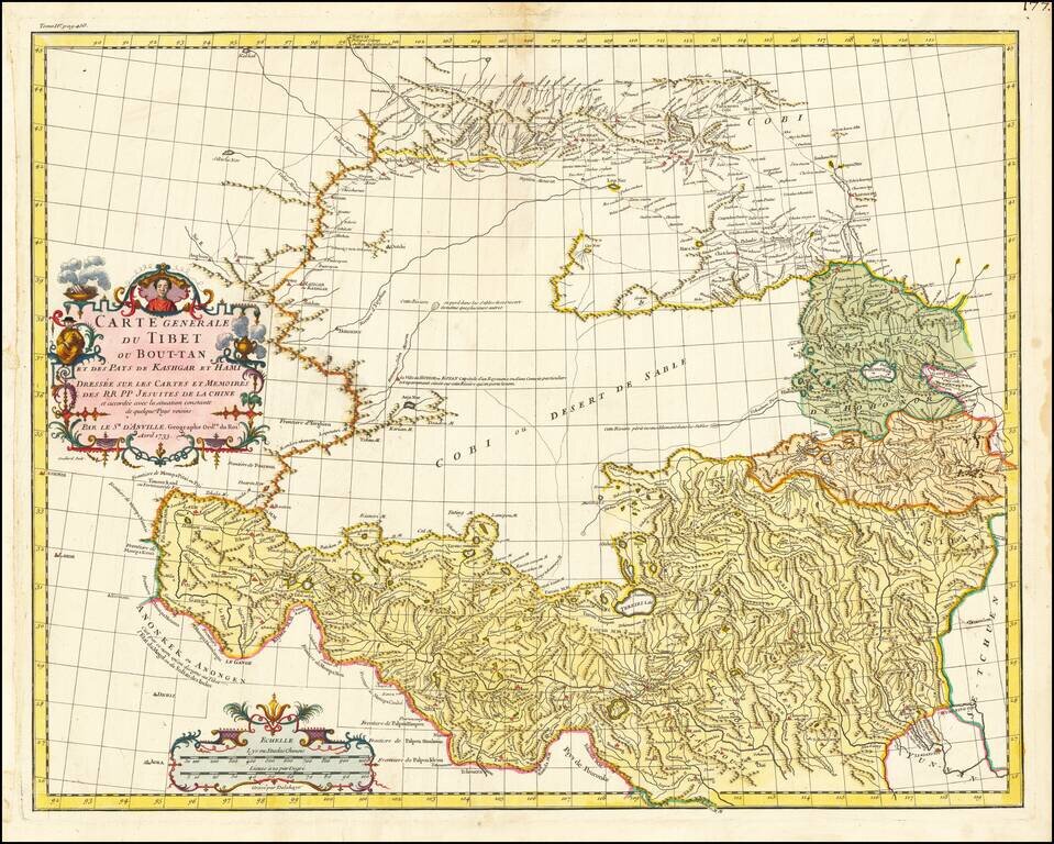
First Euopean Map of Tibet
Fine old color example of the first European map of Tibet, first issued in 1737 by D'Anville.
Much of the interior is captioned "Gobi ou Desert De Sable" (Gobi, or Sandy Desert) and several rivers are shown "lost" in the sands. There are numerous place names in the mountainous terrain surrounding the desert. A portrait bust of the Dalai Lama is featured in the cartouche which also depicts a monk and incense burners.
Jean Baptiste Bourguignon d' Anville (1697-1782) was a French cartographer and compiled over 200 maps. This map is from his most important work, Nouvel Atlas de la Chine, published in The Hague 1737.
D'Anville's atlas was the principal cartographic authority on China during the 18th century. D'Anville used maps prepared by Jesuit missionaries and commissioned by Emporer-Kanyx, who in 1708-1716 ordered a surveying of the country. This map is the first accurate cartographic depiction of Tibet available in the western world.
Jean-Baptiste Bourguignon d’Anville (1697-1782) was one of the foremost French geographers of the eighteenth century. He carried out rigorous research in order to create his maps, which greatly developed the technical proficiency of mapmaking during his lifetime. His style was also simpler and less ornate than that of many of his predecessors. It was widely adopted by his contemporaries and successors.
The son of a tailor, d’Anville showed cartographic prowess from a young age; his first map, of Ancient Greece, was published when he was only fifteen years old. By twenty-two, he was appointed as one of the King’s géographes ordinaire de roi. He tutored the young Louis XV while in the service to the Crown. However, royal appointment did not pay all the bills, so d’Anville also did some work for the Portuguese Crown from 1724. For example, he helped to fill out Dom João V’s library with geographical works and made maps showing Portugal’s African colonies.
D’Anville disapproved of merely copying features from other maps, preferring instead to return to the texts upon which those maps were based to make his own depictions. This led him to embrace blank spaces for unknown areas and to reject names which were not supported by other sources. He also amassed a large personal map library and created a network of sources that included Jesuits in China and savants in Brazil. D’Anville’s historical approach to cartography resulted in magnificently detailed, yet modern and academic, maps. For example, his 1743 map of Italy improved upon all previous maps and included a memoir laying out his research and innovations. The geographer also specialized in ancient historical geography.
In 1773, d’Anville was named premier géographe de roi. In 1780, he ceded his considerable library to the Ministry of Foreign Affairs to be used for as a reference library for diplomats. D’Anville is best known for several maps, including his map of China, first published in 1735, and then included with Du Halde’s history of that country (the Hague, 1737). His map of Africa (1749) was used well into the nineteenth century.
If you are a student, write to us in telegram: @antiquemaps and indicate what material you need and for what work you need a map in high detail. We are ready to provide material on special terms. For students only!
![[Martin Behaim Globe / Book] Pars Globi terrestris Ao. 1492 a Martino Behaim Equite Lusitano Norimbergae confecti Delineavit Christoph. Theoph de Murr 1778 (bound with:) Diplomatische Geschichte des Portugesischen berühmten Ritters Martin Behaims](/map/small/68828.jpg)
![Il Disegno Della Terza Parte Dell' Asia [Gastaldi's Wall Map of SE Asia with extra panels!]](/map/small/30554hbp.jpg)
![Chinae, olim Sinarum regionis nova descriptio. auctore Ludouico Georgio. [English Edition!]](/map/small/71123.jpg)