Map size in jpg-format: 30.8888MiB
Click to open in high resolution (open in new tab).
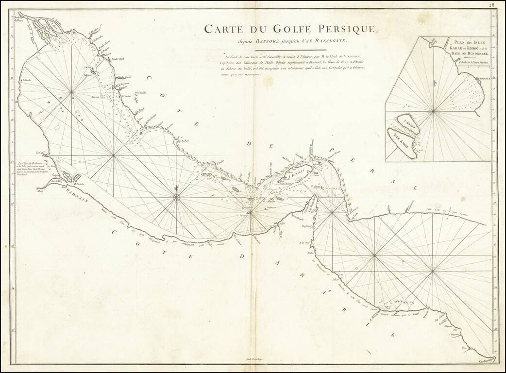
A rare antique map of the Persian Gulf and Gulf of Oman. Designed for navigational use by the French East India Company, this map is neatly designed and shows rhumb lines, bathymetric soundings, prevailing currents, and shoals. This chart is designed solely for navigation and no features which cannot seen from the coast are included.
The map includes an early reference to Qatar. The town labelled Deh-Rogn on an island near the coast of Bahrain transliterates to "the village at Ras Rakan," referring to a geographical feature of a small spit at the northernmost point of the peninsula. Interestingly, an island labelled Samaca lies to the east, so Qatar and Bahrain may have been interchanged on this map. The area to the south of Qatar is described as "little frequented, thus little known." Other geographical details are overlooked, especially in the south of the map near the present day United Arab Emirates. The pearl banks of the southern gulf are yet to become famous and remain unmarked. Some inaccuracies are recorded in the map, such as Daba [Dubai] being placed on the Omani coast.
About the map, Biedermann says "It is interesting to note that, despite the fact that the shape of the Gulf is rooted in the Dutch tradition that we have come to name after Cornelis Roobacker, there are many new place names that were not there in the earlier decades. Like some other items from this period, this map is thus a precious document of the shifting commercial geography of Persia and the Persian Gulf" (Historical Atlas of the Persian Gulf, p. 290).
Inset map of Khark and Kharko and the harbor of Bandar Rig in the northern Gulf. Bandar Rig was controlled at the time by Mir Muhanna, and was the scene of frequent small conflict during the period. The port was desired by the Dutch and British East India Companies, though Mir Muhanna repeatedly defended the area to varying degrees of success. See Cambridge History of Iran, Volume 7, pages 86-89.
This is from the Oriental Neptune, plate 28. Published from 1745 to 1775. The 1775 version as can be discerned from the addition of details including Deh-Rogn and the updated inset map.
If you are a student, write to us in telegram: @antiquemaps and indicate what material you need and for what work you need a map in high detail. We are ready to provide material on special terms. For students only!

![[Europe, Mediterranean, Asia Minor and the Persian Empire]](/map/small/43558.jpg)
