Map size in jpg-format: 48.4435MiB
Click to open in high resolution (open in new tab).
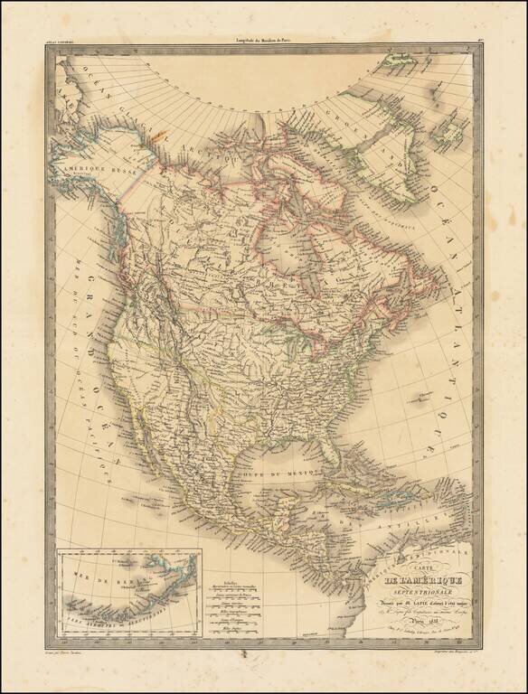
Highly detailed map of North America, with marvelous post Lewis & Clark pre-Fremont cartography. The 54-40 or Fight border of Oregon Territory is shown, with a number of early forts and Hudson Bay Company posts shown in the Northwest. The course of the Columbia and its tributaries are well described for the period, showing the results of Lewis & Clark's expedition. In California, two rivers from from the Pacific to the two Salt Lakes in Utah, one starting south of Monterrey (R. Buenaventura) and the other from San Francisco Bay (R. Millers--one of the rare appearances of this ephemeral name). Nice detail in Texas and throughout the Southwest, pre-dating Fremont's expeditions but likely with some knowledge of Jedidiah Smith's travels, which had by now appeared in French travel literature. Beginning in the early 19th Century, Lapie was one of the leading French mapmakers, at a time when much of the great exploration and travel literature was being published in French. Lapie was often the engraver of maps which were included in these books. As a result, he often incorporated the most recent information and discoveries in his maps, often appearing prior to the official report from which the information derived. His maps are now prized for their detail, accuracy and attractive engraving style.
If you are a student, write to us in telegram: @antiquemaps and indicate what material you need and for what work you need a map in high detail. We are ready to provide material on special terms. For students only!


![[Signed Political Satire Artwork] Vietnam ... Vietnam ... Vietnam ...](/map/small/68726.jpg)