Map size in jpg-format: 9.55641MiB
Click to open in high resolution (open in new tab).
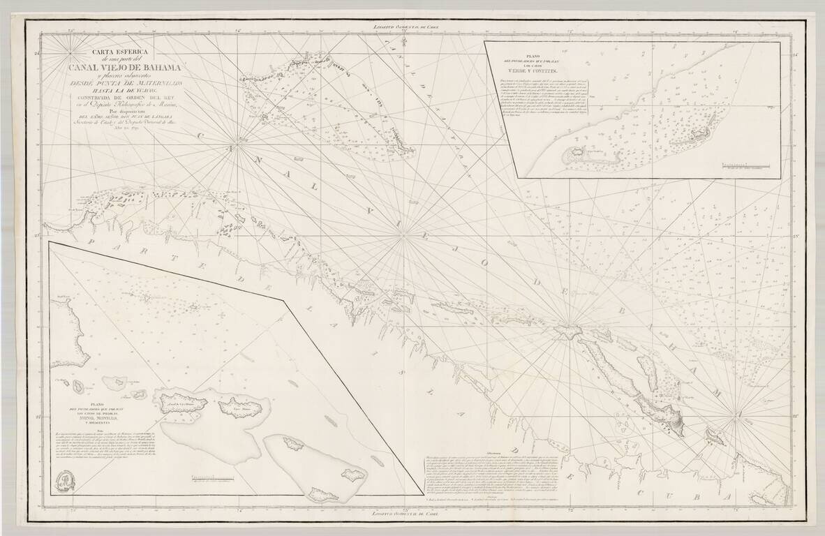
Early edition of this important Spanish chart of part of the Bahama Channel and the northern coastline of Cuba, published by the Spanish Admiralty.
First issued in 1799, this example adds rhumb lines not on the earlier state of the chart.
This is the first modern chart of the region, based upon Spanish surveys under the direction of Don Juan de Langara. The chart shows the northern coast of Cuba with the many atolls and islands to the north and along the Old Bahama Channel. Insets: "Plano del fondeadero que forman los cayos de piedras, mono, monillo, y adyacentes" and "Plano del fondeadero que forman los cayos verde y confites."
Juan Francisco de Lángara y Huarte (1736-1806) was a prominent Spanish naval commander, who served for over 50 years in the Spanish Navy, rising to the level of Secretary of the Navy. Under his direction, some of the most important modern surveys in the Gulf Coast, Caribbean and other parts of Spanish America were made. During Lángara's period at the head of the Spanish navy, Spanish explorers were charting the coast of what is now British Columbia, Canada, and, in their charts, named some land formations after him. His name is still found among place names in British Columbia, including Langara Island, off the coast of northern BC, and Langara College in Vancouver.
The Dirección de Hidrografía, or the Directorate of Hydrographic Works, was established in 1797. Its roots were in the Casa de Contratación, founded in 1503 in Sevilla, which housed all the charts of the Spanish Empire and oversaw the creation and maintenance of the padrón real, the official master chart. The Casa, now in Cadiz, was shuttered in 1790, but Spain still needed a hydrographic body. In response, the Dirección was created in 1797. One of its first projects was the publication of charts from the Malaspina Expedition (1789-1794). The Dirección oversaw not only publication, but also surveying. The Dirección was abolished in the early twentieth century, when their work was distributed to other organizations.
If you are a student, write to us in telegram: @antiquemaps and indicate what material you need and for what work you need a map in high detail. We are ready to provide material on special terms. For students only!


![[Wall Map] West-Indische Paskaert waer in de graden der breedde over weder zyden vande middelyn wassende so vergrooten dat die geproportioneert syn tegen hunne nevenstaende graden de lengde.](/map/small/60169.jpg)