logo

1858. Boundary of the Creek Country Surveyed Under The Direction of the Bureau of Topl. Engs. . . 1849 (with text report)

  • Boundary of the Creek Country Surveyed Under The Direction of the Bureau of Topl. Engs. . . 1849 (with text report)

Boundary of the Creek Country Surveyed Under The Direction of the Bureau of Topl. Engs. . . 1849 (with text report) information:

Year of creation: 
Resolution size (pixels): 
 23061x15041 px
Disk Size: 
 54.6882MiB
Number of pages: 
 1
Place: 
 Washington

Print information. Print size (Width x height in inches):
Printing at 72 dpi 
  320.29 х 208.9
Printing at 150 dpi 
 153.74 х 100.27
Printing at 300 dpi 
 76.87 х 50.14

An example of detailing the file of this map of in a printable high-resolution:

Click to open in high resolution (open in new tab).
Attention! this is just the central piece (central area 960x960 px) of the map file!
This is an example, so that you can see and study the level of detail of a given map. The entire Map will be fully available after payment!

Boundary of the Creek Country Surveyed Under The Direction of the Bureau of Topl. Engs. . . 1849 (with text report)

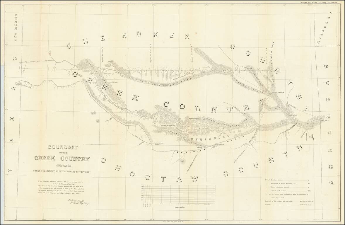
Detailed survey of the lands in Indian Territory occupied by the Creek Indians by agreement with the United States Government.

The map shows the results of the earliest surveys of the watershed of the Canadian River and Red Fork of the Arkansas River in Indian Territory. It extends from Fort Smith to the border with Texas, and was conducted under the diredtion of Lorenzo Sitgreaves and J.C.Woodruff.

The lands of the Cherokee, Creek, Seminole and Choctaw Indians are located. The map locates numerous forts, including Smith, Coffee, Gibson and Old Fort Holmes, and their connecting wagon roads. Talasee is shown at the site of Tulsa. This map was issued with the "Northern and Western Boundary Line of the Creek Country" report by Sitgreaves and Lt. J.C. Woodruff.

The surveys were made in 1848 and 1850, but the report in which the map was issued wasn't published until 1858.

The present example includes the text report.


Special conditions for students!

If you are a student, write to us in telegram: @antiquemaps and indicate what material you need and for what work you need a map in high detail. We are ready to provide material on special terms. For students only!

Item information:

Year of creation:
Size:
23061x15041 px
Disk:
54.6882MiB
Number of pages:
1
Place:
Washington
Author:
United States War Dept..
$21.99

Related item