logo

1584. Beschrijvinghe der Zee Custen vant Landt va Argarbe En ee deel vande Condado, Soe hem tlandt aldaer verthoonten in ghendaente en mesen is -- Algarbae orae maritimae, et partis Coridadae accurata descriptio, ac facies navigantibus apparens

  • Beschrijvinghe der Zee Custen vant Landt va Argarbe En ee deel vande Condado, Soe hem tlandt aldaer verthoonten in ghendaente en mesen is --  Algarbae orae maritimae, et partis Coridadae accurata descriptio, ac facies navigantibus apparens

Beschrijvinghe der Zee Custen vant Landt va Argarbe En ee deel vande Condado, Soe hem tlandt aldaer verthoonten in ghendaente en mesen is -- Algarbae orae maritimae, et partis Coridadae accurata descriptio, ac facies navigantibus apparens information:

Year of creation: 
Resolution size (pixels): 
 6389x4289 px
Disk Size: 
 7.58579MiB
Number of pages: 
 1
Place: 
 Antwerp

Print information. Print size (Width x height in inches):
Printing at 72 dpi 
  88.74 х 59.57
Printing at 150 dpi 
 42.59 х 28.59
Printing at 300 dpi 
 21.3 х 14.3

An example of detailing the file of this map of in a printable high-resolution:

Click to open in high resolution (open in new tab).
Attention! this is just the central piece (central area 960x960 px) of the map file!
This is an example, so that you can see and study the level of detail of a given map. The entire Map will be fully available after payment!

Beschrijvinghe der Zee Custen vant Landt va Argarbe En ee deel vande Condado, Soe hem tlandt aldaer verthoonten in ghendaente en mesen is --  Algarbae orae maritimae, et partis Coridadae accurata descriptio, ac facies navigantibus apparens

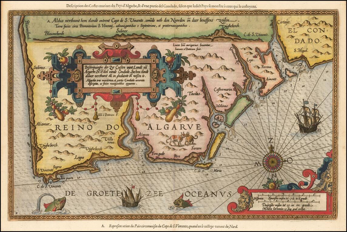
Striking full color example of Wagenhaer's map of the Algarve coastline, extending from just north of Sines in Portugal and the Lagos area to the Rio de Piedras area in Spain.

Wagenhaer was a Dutch pilot who produced the first set of effective navigational charts, under the title Spiegel der Zeevaerdt. These gorgeous charts, engraved by Baptist and Jan van Doetecum, embody the latest contemporary knowledge of navigation and position finding and set the standard which was followed for more than a century. Waghenaer's charts are magnificent works of art, which are highly sought after by collectors.

An essential map for collectors of the region and the earliest decorative sea chart of the region.


Special conditions for students!

If you are a student, write to us in telegram: @antiquemaps and indicate what material you need and for what work you need a map in high detail. We are ready to provide material on special terms. For students only!

Item information:

Year of creation:
Size:
6389x4289 px
Disk:
7.58579MiB
Number of pages:
1
Place:
Antwerp
Author:
Lucas Janszoon Waghenaer.
$14.99

Related item