logo

1760. Barbados

  • Barbados

Map size in jpg-format: 17.9672MiB

Download "Barbados", in high resolution.

Barbados information:

Year of creation: 
Resolution size (pixels): 
 7235x10899 px
Disk Size: 
 17.9672MiB
Number of pages: 
 1
Place: 
 London
Author: 

Print information. Print size (Width x height in inches):
Printing at 72 dpi 
  100.49 х 151.38
Printing at 150 dpi 
 48.23 х 72.66
Printing at 300 dpi 
 24.12 х 36.33

An example of detailing the file of this map of in a printable high-resolution:

Click to open in high resolution (open in new tab).
Attention! this is just the central piece (central area 960x960 px) of the map file!
This is an example, so that you can see and study the level of detail of a given map. The entire Map will be fully available after payment!

Barbados

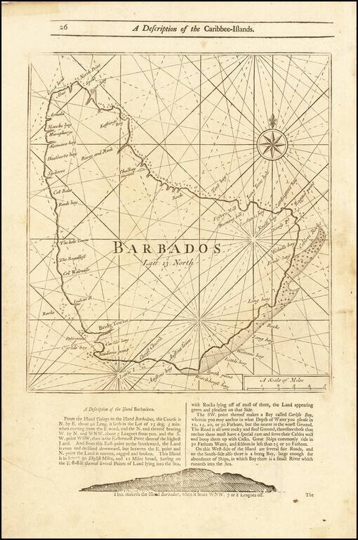
Detailed coastal map of the Island of Barbados, from Mount & Page's English Pilot, Fourth Book.

The map includes a number of bays, harbors and other coastal feature, with sailing directions and a profile view below and on the verso.


Special conditions for students!

If you are a student, write to us in telegram: @antiquemaps and indicate what material you need and for what work you need a map in high detail. We are ready to provide material on special terms. For students only!

Item information:

Year of creation:
Size:
7235x10899 px
Disk:
17.9672MiB
Number of pages:
1
Place:
London
Author:
Mount & Page.
$14.99

Related item