Map size in jpg-format: 58.1881MiB
Click to open in high resolution (open in new tab).
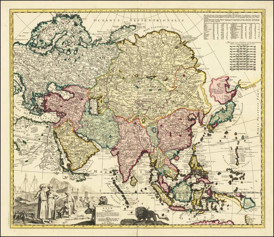
Scarce of map of Asia, published in Amsterdam.
The map bears the additional names of Peter Schenk and Nicholas Visscher.
The northeast coastline is shown with Witsen's information on Siberia. Hokkaido and Honshu (Terra Yedso) are joined together by a narrow isthmus and separated from the mainland by a wide straight.
An accompanying note acknowledges Scherer as the source, although the orientation of Yedso and Companies Land appears to be based on the De L'Isle model.
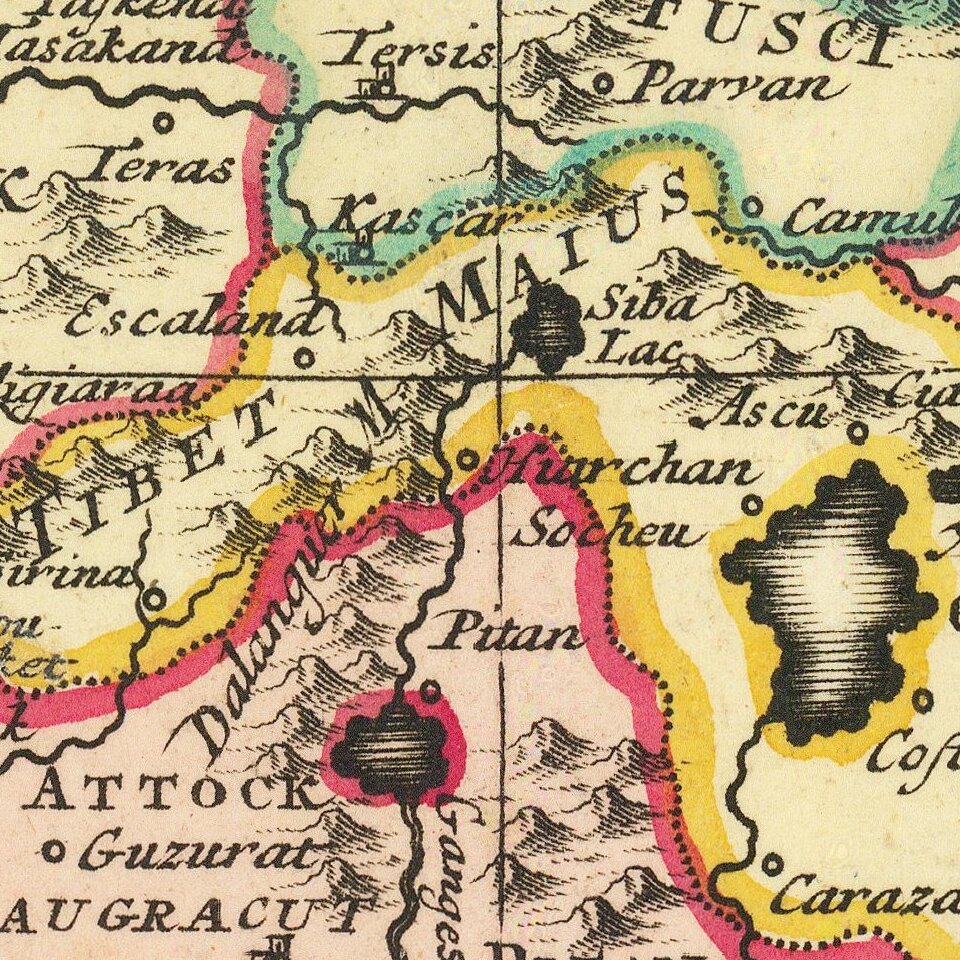
A huge lake appears in Tibet -- the legendary Lake Chiamay. A second lake is shown in the position usually occupied by Lake Chiamay, but here it is named L. Cananor Cimabete.
In Southeast Asia the straits between New Guinea and Australia appear in a tentative fashion, noting Dampier's Strait and a disembodied Carpenteria with no definite northern limit.
The map is decorated with a large, uncolored cartouche featuring Arab merchants, a fort, a pair of leopards and a fierce lion.
North Pacific chimeras: Eso, De Gama, and Compagnie Land
Historically, Eso (Yeco, Jesso, Yedso, Yesso) refers to the island of Hokkaido. It varies on maps from a small island to a near-continent sized mass that stretches from Asia to Alaska. Eso is often tied to two other mythical North Pacific lands, Gamaland and Compagnies Land.
Juan de Gama, the grandson of Vasco de Gama, was a Portuguese navigator who was accused of illegal trading with the Spanish in the East Indies. Gama fled and sailed from Macau to Japan in the later sixteenth century. He then struck out east, across the Pacific, and supposedly saw lands in the North Pacific. These lands were initially shown as small islands on Portuguese charts, but ballooned into a continent-sized landmass in later representations.
Several voyagers sought out de Gama’s lands, including the Dutchmen Matthijs Hendrickszoon Quast in 1639 and Maarten Gerritszoon Vries in 1643. Compagnies Land, often shown along with Staten Land, were islands sighted by Vries on his 1643 voyage. He named the islands for the Dutch States General (Staten Land) and for the Dutch East India Company (VOC) (Compagnies, or Company’s Land). In reality, he had re-discovered two of the Kuril Islands. However, other mapmakers latched onto Compagnies Land in particular, enlarging and merging it with Yesso and/or Gamaland.
In the mid-eighteenth century, Vitus Bering, a Danish explorer in Russian employ, and later James Cook would both check the area and find nothing. La Perouse also sought the huge islands, but found only the Kurils, putting to rest the myth of the continent-sized dream lands.
Adam Friedrich Zürner (15 August 1679 – 18 December 1742) was a German Protestant priest, cartographer and the head of construction of the Kursächsische Postmeilensäulen in Saxony.
Zurner's first project of note was a map of Saxony, for which he was retained by August III, King of Poland, in 1711.
Zurner was appointed Geographer of Poland and the Electorate of Saxony, a position in which he served until 1732. In this time period, he reportedly traveled nearly 18,000 miles and created over 900 maps.
In 1721, he was tasked with establishing a postal road system in Saxony and marking the distances with stone posts.
His work resulted in the Atlas Augusteus Sauronicus (40 maps plus key sheet), which remained incomplete until after Zurner's death, but was ultimately sold to Pieter Schenk in Amsterdam in about 1745. Schenk's completed work (49 maps, published in Amsterdam and Leipzig) was issued without reference to Zurner's name, under the title Atlas Saxonicus.
Despite his prolific work product, none of Zurner's original manuscript maps seem to survive.
If you are a student, write to us in telegram: @antiquemaps and indicate what material you need and for what work you need a map in high detail. We are ready to provide material on special terms. For students only!

![[Eastern Hemisphere Globe Gores] (Nova et integra universi Orbis descriptio)](/map/small/54480.jpg)