logo

1692. Arabia

  • Arabia

Map size in jpg-format: 2.15028MiB

Download "Arabia", in high resolution.

Arabia information:

Year of creation: 
Resolution size (pixels): 
 2004x3693 px
Disk Size: 
 2.15028MiB
Number of pages: 
 1
Place: 
 Frankfurt
Author: 

Print information. Print size (Width x height in inches):
Printing at 72 dpi 
  27.83 х 51.29
Printing at 150 dpi 
 13.36 х 24.62
Printing at 300 dpi 
 6.68 х 12.31

An example of detailing the file of this map of in a printable high-resolution:

Click to open in high resolution (open in new tab).
Attention! this is just the central piece (central area 960x960 px) of the map file!
This is an example, so that you can see and study the level of detail of a given map. The entire Map will be fully available after payment!

Arabia

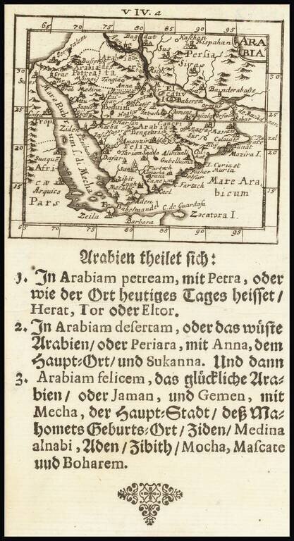
Rare map of the Arabian Peninsula, published by Johann Ulrich Muller.

The Arabian Sea is called M[are] El Catif, with the Island of Bahrain shown. The Red Sea is alternatively named Sea of Mecha. Many other early place names.

Many other interesting features. From one of the rarest and most coveted of all miniature atlases.


Special conditions for students!

If you are a student, write to us in telegram: @antiquemaps and indicate what material you need and for what work you need a map in high detail. We are ready to provide material on special terms. For students only!

Item information:

Year of creation:
Size:
2004x3693 px
Disk:
2.15028MiB
Number of pages:
1
Place:
Frankfurt
Author:
Johann Ulrich Muller.
$14.99

Related item