logo

1762. An accurate Map of England, Scotland, and Ireland, with all the adjacent Islands, from the latest Improvements.

  • An accurate Map of England, Scotland, and Ireland, with all the adjacent Islands, from the latest Improvements.

An accurate Map of England, Scotland, and Ireland, with all the adjacent Islands, from the latest Improvements. information:

Year of creation: 
Resolution size (pixels): 
 6658x8685 px
Disk Size: 
 15.5766MiB
Number of pages: 
 1
Place: 
 London

Print information. Print size (Width x height in inches):
Printing at 72 dpi 
  92.47 х 120.63
Printing at 150 dpi 
 44.39 х 57.9
Printing at 300 dpi 
 22.19 х 28.95

An example of detailing the file of this map of in a printable high-resolution:

Click to open in high resolution (open in new tab).
Attention! this is just the central piece (central area 960x960 px) of the map file!
This is an example, so that you can see and study the level of detail of a given map. The entire Map will be fully available after payment!

An accurate Map of England, Scotland, and Ireland, with all the adjacent Islands, from the latest Improvements.

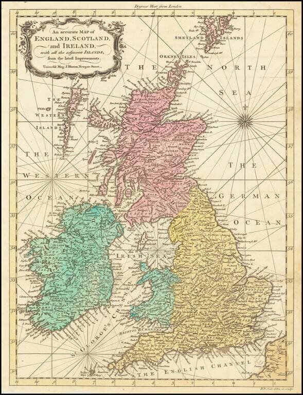
Scarce old color example of R.W. Seale's map of Great Britain, which appeared in the Universal Magazine in 1762.

The map incorporate rhumb lines, a feature typical of working sea charts of the 18th Century.


Special conditions for students!

If you are a student, write to us in telegram: @antiquemaps and indicate what material you need and for what work you need a map in high detail. We are ready to provide material on special terms. For students only!

Item information:

Year of creation:
Size:
6658x8685 px
Disk:
15.5766MiB
Number of pages:
1
Place:
London
Author:
Richard William Seale.
$14.99

Related item