Map size in jpg-format: 37.7333MiB
Click to open in high resolution (open in new tab).
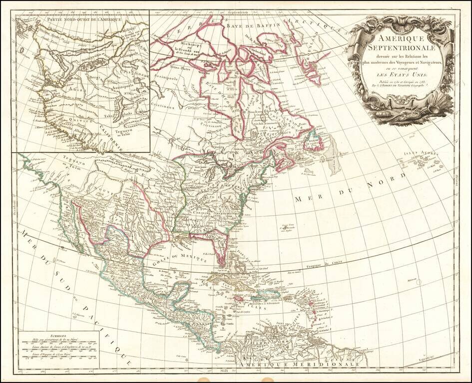
Scarce late state of De Vaugondy's map of North America, published in Paris.
First issued in the 1750s, this edition has been updated to include the newly formed United States.
Florida is shown as an archipelago and the coastline of California is quite curious, with a continuation of the coastline in the inset map showing some of the mythical cartography, such as the Sea of the West and River of the West, which were debated among map scholars and explorers until Captain James Cook dispelled these myths in his three Voyages to the Pacific.
The map also locates the area identified as Fou-sang, reflecting the belief that Chinese mariners may have reached America, the location of the mythical colony of Fou-sang. According to some historians such as Charles Godfrey Leland and Joseph de Guignes ( Le Fou-Sang des Chinois est-il l'Amérique Mémoires de l'Académie des Inscriptions et Belles Lettres, tome 28, Paris, 1761), the distances given by Hui Shen (20,000 Chinese li) would locate Fou-sang on the west coast of the American continent, near British Columbia.
A nice example of this interesting map.
Gilles Robert de Vaugondy (1688-1766) was the head of a leading family of geographers in eighteenth century France. Gilles got his start when he jointly inherited the shop of Pierre-Moullart Sanson, grandson of the famous geographer Nicholas Sanson. The inheritance included the business, its stock of plates, and a roller press. In 1760 Gilles became geographer to King Louis XV. His son, Didier Robert de Vaugondy (ca. 1723-1786), was also a geographer and the two worked together. They were known for their exactitude and depth of research. In 1757, they produced the Atlas Universel, considered an authority for many years.
If you are a student, write to us in telegram: @antiquemaps and indicate what material you need and for what work you need a map in high detail. We are ready to provide material on special terms. For students only!

![[Signed Political Satire Artwork] Vietnam ... Vietnam ... Vietnam ...](/map/small/68726.jpg)
