logo

1862. Amerique du Nord . . . (Arizona below New Mexico / Idaho below Wyoming!)

  • Amerique du Nord . . .   (Arizona below New Mexico / Idaho below Wyoming!)

Amerique du Nord . . . (Arizona below New Mexico / Idaho below Wyoming!) information:

Year of creation: 
Resolution size (pixels): 
 13970x18659 px
Disk Size: 
 63.8024MiB
Number of pages: 
 1
Place: 
 Paris

Print information. Print size (Width x height in inches):
Printing at 72 dpi 
  194.03 х 259.15
Printing at 150 dpi 
 93.13 х 124.39
Printing at 300 dpi 
 46.57 х 62.2

An example of detailing the file of this map of in a printable high-resolution:

Click to open in high resolution (open in new tab).
Attention! this is just the central piece (central area 960x960 px) of the map file!
This is an example, so that you can see and study the level of detail of a given map. The entire Map will be fully available after payment!

Amerique du Nord . . .   (Arizona below New Mexico / Idaho below Wyoming!)

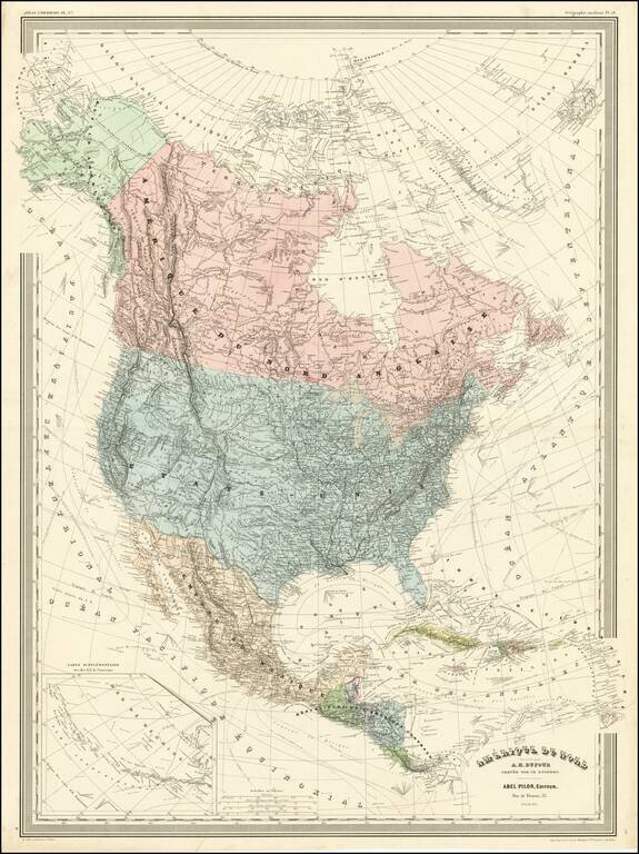
Detailed wall map of North America, published by A.H. Dufour.

Arizona is below New Mexico (the Baylor Line), a vestige of the attempt to create a slave and non-slave territory prior to the Civil War. Colorado is named (the map shows Colona in the prior edition).

Nevada and Utah are in early configurations, with the boundary still at 2 degrees to the west and the bottom of Nevada truncated.

Montana is named, with a massive Idaho below, pre-dating Wyoming.

A highly detailed and scarce map.


Special conditions for students!

If you are a student, write to us in telegram: @antiquemaps and indicate what material you need and for what work you need a map in high detail. We are ready to provide material on special terms. For students only!

Item information:

Year of creation:
Size:
13970x18659 px
Disk:
63.8024MiB
Number of pages:
1
Place:
Paris
Author:
Adolphe Hippolyte Dufour.
$14.99

Related item