Map size in jpg-format: 13.3419MiB
Click to open in high resolution (open in new tab).
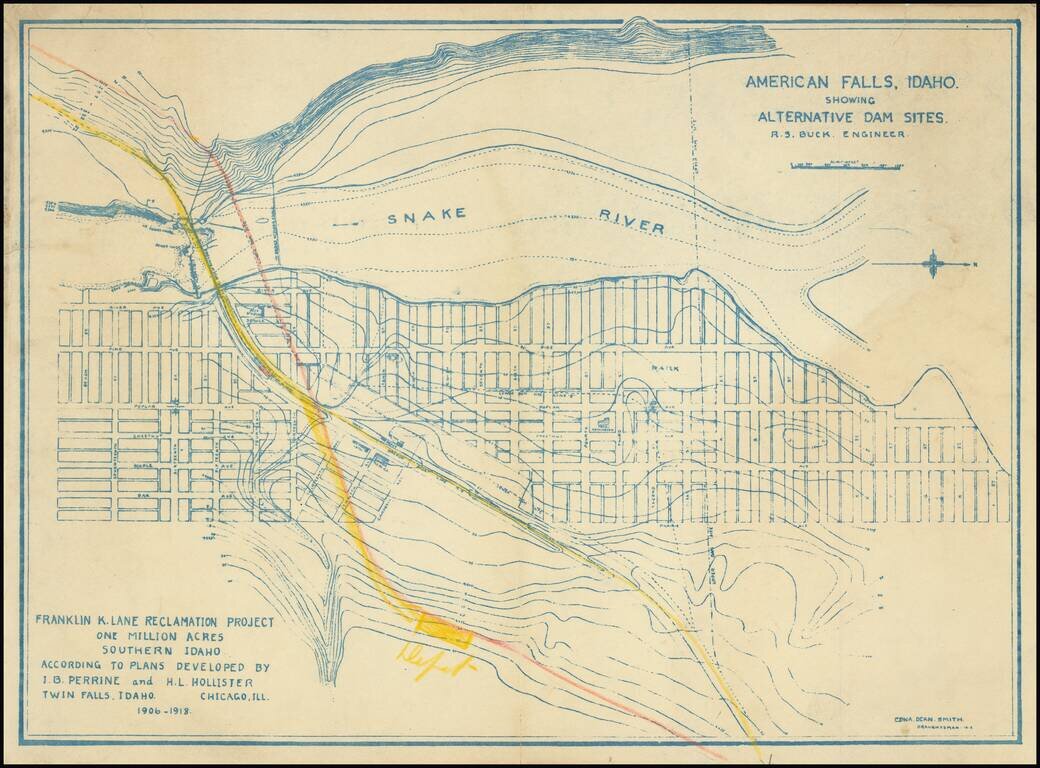
Relocating A Town To Construct the American Falls Dam
Topographical plan of the area around American Falls, Idaho and the American Falls, Dam on the Snake River, drawn by Edna Dean Smith.
The map was prepared in connection with the "Franklin K. Lane Reclamation Project, One Million Acres, Southern Idaho, According To Plans Developed by J.B. Perrine of Twin Falls Idaho and H.L. Hollister of Chicago, ILL., 1906-1918.
American Falls
The first permanent settlement of American Falls was founded in 1800 and located on the West bank of the Snake River, on the opposite side of the river from the present location. In 1888, the “town” was moved across the river to what is now called “original town site”.
In 1925, the Bureau of Reclamation decided to relocate the town again to make way for the American Falls Dam. The most difficult part of building the 94-foot-high and 5,277-foot-long composite concrete and earthen dam was not its construction and financing, but resolving the problems that the 23 mile long reservoir would have on the businesses. In all 344 residents, 46 businesses, three hotels, one school, five churches, one hospital, six grain elevators, and one flour mill were moved from the original town site, making this the largest government relocation project of its time. Depending on the quality of the building, dwellings would be relocated to one of three neighborhoods on the east, south and west side of the new town square.
The new city was platted on higher ground and had a park in the center of town. Commerce lots would be on one side of the square faced by the government buildings on the other. Churches were to situated on the other two sides of the park, and homes were platted out from there. The alignment of the streets was not without controversy. The streets were laid out diagonally; parallel to the reservoir shore.
The Oneida Milling and Elevator Company’s grain elevator was the only structure that was not moved. Its 40-foot-deep foundation and 106-foot reinforced concrete walls still stand with its top rising above the water. It stands as a silent reminder of the remarkable history of American Falls.
The Dam was completed sixty days ahead of schedule on April 21, 1926. The dam’s gates where shut and the spring run-off started to collect in the reservoir which would eventually cover twenty-five miles upstream. On July 29, 1926 the “moving road” across the Dam was officially closed, ending the relocation of American Falls.
If you are a student, write to us in telegram: @antiquemaps and indicate what material you need and for what work you need a map in high detail. We are ready to provide material on special terms. For students only!