Map size in jpg-format: 24.9945MiB
Click to open in high resolution (open in new tab).

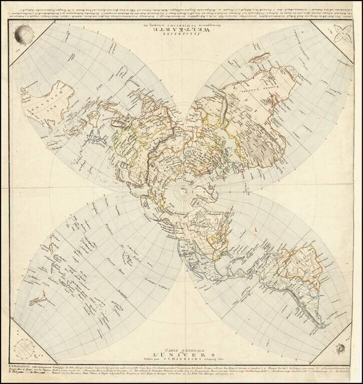
Striking, Innovative German World Map -- Projecting The Globe on A Flat Surface
Distinctive world map published by German publisher Johann Conrad Hinrichs. It is an unusual azimuthal stereographic projection, which is then split into four lobes -- an attempt to cut the globe into 4 sections and project the image on a flat surface.
The map is on a stereographic projection, centered at the North Pole, which continues to just below 40°N latitude. Then the map splits into four lobes containing Australia, Africa, South America, and the Pacific (clockwise from the upper left corner). The map is conformal, meaning it preserves shapes. The lobes help to avoid distortion as the map radiates out from the projection point. The construction of the innovative projection is explained in a series of figures in the four corners of the map.
At either top of the map—it rotates so that it can be read in French when one side is up, in German when the other is up—is an explanation. It translates as:
This map presents the envelope [surface] of the globe, cut and removed (as in fig 3), then laid flat on a table (as in fig. 4). Its illumination [coloring] presents, 1. the possessions of Great Britain in Europe, Asia, Africa and America in dark red, 2. Of Spain, blue, 3. Of Portugal, yellow orange, 4. Possession and Turkish domination of Europe, Asia and Africa, with the Barbary Kingdoms, in green, 5. Russian possessions in Europe and Asia, yellow. Then in Europe, the French domination, in water color; the Danish possessions, grey; Swedish, red; Prussian, violet; Austrian, red; Sicilian, violet; Sardinian, red. In Asia, Persian, red; Tibet, yellow; China, green. All the other powers, states, nations and independent peoples of Europe, Asia, Africa and America are in brown. The United States of America in yellow.
Published in 1811, the map has a few lacunae that jump out to the modern eye. Alaska is unfinished in the far north, as is much of the interior far north of what is today Canada. The great exploratory nineteenth-century expeditions in search of the Northwest Passage had yet to happen, leaving much of this area unknown to Europeans.
The place names in the Pacific Northwest of North America come from the voyage of George Vancouver (1791-1795), as his voyage account was published in 1798. New Zealand is patterned after the map of Captain James Cook, who visited the islands on all three of his Pacific voyages. The voyages of Bering, Byron, and other explorers are also included.
However, the geography clarified by another contemporary explorer, Matthew Flinders, has not been fully integrated here. Flinders led the second circumnavigation of Australia; the first, much broader circumnavigation was made by Abel Tasman in the 1640s. Flinders sailed in the Investigator in 1801, carefully charting the south coast of Australia en route to Sydney. Then from 1802-1803 he circled the entire continent, making even more skilled charts. However, on his return to England, Flinders was forced to land at Mauritius and was taken prisoner by the French. He was kept there for seven years, returning to England only in late 1810.
Another expedition was also charting Australia when Flinders was, and a map from this voyage, led by the Frenchman Baudin, was published by Freycinet in 1811, the same year this map was published. Flinders’ maps and charts of the continent officially appeared in 1814, although information of his voyage circulated prior to that date. Neither voyage seems to have affected the mapping of Australia here. The Australia on Hinrichs’ map has dotted lines connecting Nuits Land, an old Dutch toponym, to the Bass Strait, an earlier Flinders discovery. The northeast coast is also incomplete near Carpentaria, as is the coast of New Guinea.
The map is certainly a cartographic curiosity, but it also shows the ingenuity of publishers and mapmakers early in the century in which cartography became an academic discipline.
Rarity
The map is very rare. We note only the example listed in "Notable Acquistions" section of the Chronicle for 1998, Imago Mundi, vol 51, p. 186 (1999) -- acquired by the Austrian National Library. The map is also referenced in the 1850 British Museum Catalog of Maps (World, p. 77).
If you are a student, write to us in telegram: @antiquemaps and indicate what material you need and for what work you need a map in high detail. We are ready to provide material on special terms. For students only!


