Map size in jpg-format: 1285140B
Click to open in high resolution (open in new tab).
Unrecorded Edition!
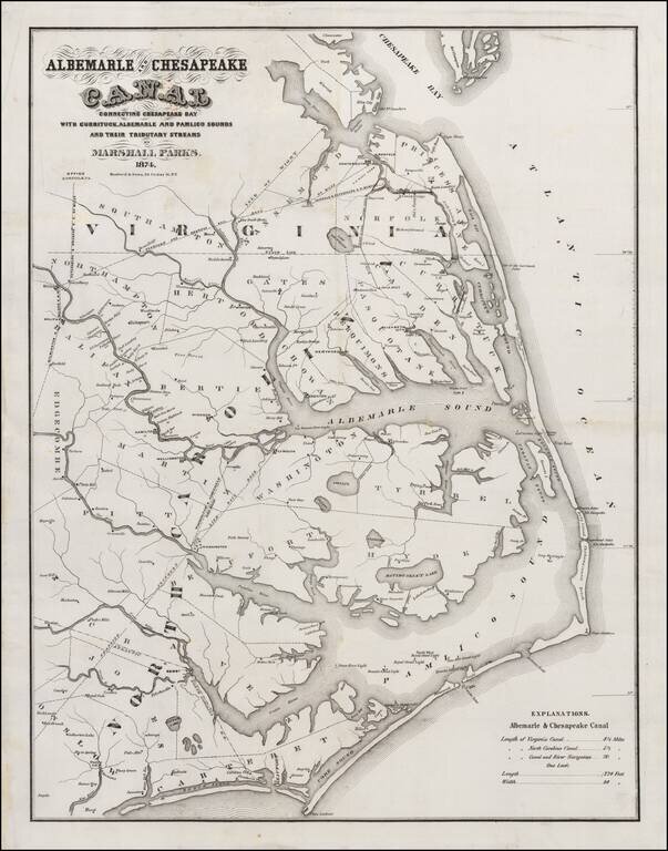
Rare separately issued map of the Ablemarle and Chesapeake Canal, one of the major engineering projects of the period south of the Mason Dixon.
The map illustrates the region between Cape Charles and Cape Lookout, showing the two parts of the Albemarle and Chesapeake Canal, including the Elizabeth River to North Landing River Section (8.5 Miles) and the Coinjock Bay to North River Section (5.5 Miles), along with detailed information in the interior of North Carolina, including rivers, towns, roads, railroads, etc.
The Albemarle & Chesapeake Canal was built between 1856 and 1860 to allow inland navigation between Chesapeake Bay and Albemarle Sound. The project consisted of two canals, thirty miles apart; one eight and one-half miles long, connecting Elizabeth River with North Landing River in Virginia, the other five and one-half miles long, connecting Currituck Sound with North River in North Carolina. First authorized in 1772, the early history of the Albemarle & Chesapeake Canal consisted of lots of legislation, but no construction. Ten different acts were passed in both Virginia and North Carolina over a period of 83 years before construction finally began in 1855.
The man who was finally able to begin the canal was Tidewater Virginian Marshall Parks, Jr. Parks' father had been superintendent and chief engineer of the Dismal Swamp Canal during its first major period of reconstruction in the late 1820s. The younger Parks had also been an official with the Dismal Swamp Canal Company and was familiar with the canal's problems. He visualized the Albemarle and Chesapeake Canal as the answer to more efficient commercial trade between the two regions.
The new canal would be wider and deeper than most others of its day. Parks planned for the Canal to handle the larger steamers and future growth. It would also have only one lock, instead of the Dismal's then seven, considerably reducing passage time. Construction of the Albemarle and Chesapeake was accomplished by seven steam dredges on floating platforms. When the canal was finished, it was an engineering marvel. It consisted of only one lock and two relatively short man-made channels, the Virginia Cut and the North Carolina Cut. The single lock, which balanced the lunar tides of the southern branch of the Elizabeth River with the wind driven ones of the North Landing River and Currituck Sound, was 40 feet wide and 220 feet long, the largest along the Atlantic coast and the second largest in the entire U.S.
Rarity
There are several editions of the map, including a Hosford & Co. editions of 1856 (OCLC locates 2 examples) 1857 (1 example), 1858 (2 examples) and 1859 (Old Print Gallery, 1986) and 1866, for which no copies are located in OCLC, although we also had an 1866 edition in 2006 and 2011.
We are not aware of any other examples of the 1874 edition of the map.
If you are a student, write to us in telegram: @antiquemaps and indicate what material you need and for what work you need a map in high detail. We are ready to provide material on special terms. For students only!


![[The First Maps in a la poupée Printed Color] Cartes en Couleur des Lieux Sujets aux tremblements de Terre Dans toutes les parties du Monde Selon le Sisteme de l’impulsion Solaire](/map/small/52293op.jpg)