Map size in jpg-format: 2.21853MiB
Click to open in high resolution (open in new tab).

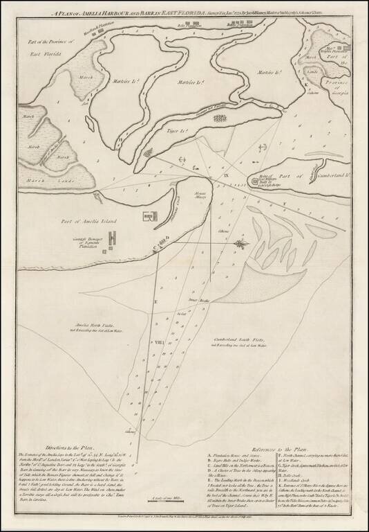
A Revolutionary War Florida Rarity.
Fine wide margined example of Sayer & Bennett's chart of Amelia Harbor and Bar, based upon a survey conducted under the direction of Jacob Blamey in January 1775.
The map is oriented with west at the top.
On Amelia Island, the Countess Dowager of Egmont's Plantation is shown, along with Mount Misery, Morriss Bluff, "Negro Hutts and Indigo Works," and a beacon. The Ruins of Fort William, built by General Oglethorpe are shown on Cumberland Island. Woodland's Plantation, Bells Plantation and Ralphs Plantation are shown in East Florida at the top of the map, while Messr Wright's Plantation is shown in Georgia at the top right.
The chart includes an extensive set of directions, soundings, and a reference key identifying 10 locations.
The map was included in Sayer & Bennett's The North-American Pilot, Part the Second. The source volume is scarce in itself. We are aware of three copies of the map on the market in the last 35 years.
Robert Sayer (ca. 1724-1794) was a prominent London map publisher. Robert’s father was a lawyer, but his older brother married Mary Overton, the widow of prominent mapmaker Philip Overton and the proprietor of his shop after his death. Mary continued the business for roughly a year after her marriage and then, in early 1748, it passed to Robert. Robert became a freeman of the Stationers’ Company later that year; his first advertisement as an independent publisher was released in December.
Sayer benefited from Overton’s considerable stock, which included the plates of John Senex. In the 1750s, Sayer specialized in design books and topographical prints, as well as comic mezzotints. In 1753, he, along with John Roque, published a new edition of Thomas Read’s Small British Atlas, the first of several county atlases that Sayer would publish.
Sayer’s business continued to grow. In 1760 he moved further down Fleet Street to larger premises at 53 Fleet Street. In 1766, he acquired Thomas Jefferys’ stock when the latter went bankrupt. In 1774, he entered into a partnership with John Bennett, his former apprentice. The pair specialized in American atlases, based on the work of Jefferys. They also began publishing navigational charts in the 1780s and quickly became the largest supplier of British charts in the trade.
Bennett’s mental health declined, and the partnership ended in 1784. As Sayer aged, he relied on his employees Robert Laurie and James Whittle, who eventually succeeded him. He spent more and more time at his house in Richmond. In 1794, he died in Bath.
If you are a student, write to us in telegram: @antiquemaps and indicate what material you need and for what work you need a map in high detail. We are ready to provide material on special terms. For students only!

![[Wall Map] West-Indische Paskaert waer in de graden der breedde over weder zyden vande middelyn wassende so vergrooten dat die geproportioneert syn tegen hunne nevenstaende graden de lengde.](/map/small/60169.jpg)
