logo

1698. A New Mapp of the Island of St. Christophers being an Actual Survey taken by Andrew Norwood Surveyr. Genll. / A New Map of the Island Guardalupa / A New Mapp of the Island Martineca

  • A New Mapp of the Island of St. Christophers being an Actual Survey taken by Andrew Norwood Surveyr. Genll.  /  A New Map of the Island Guardalupa   /  A New Mapp of the Island Martineca

A New Mapp of the Island of St. Christophers being an Actual Survey taken by Andrew Norwood Surveyr. Genll. / A New Map of the Island Guardalupa / A New Mapp of the Island Martineca information:

Year of creation: 
Resolution size (pixels): 
 13395x10986 px
Disk Size: 
 29.5657MiB
Number of pages: 
 1
Place: 
 London
Author: 

Print information. Print size (Width x height in inches):
Printing at 72 dpi 
  186.04 х 152.58
Printing at 150 dpi 
 89.3 х 73.24
Printing at 300 dpi 
 44.65 х 36.62

An example of detailing the file of this map of in a printable high-resolution:

Click to open in high resolution (open in new tab).
Attention! this is just the central piece (central area 960x960 px) of the map file!
This is an example, so that you can see and study the level of detail of a given map. The entire Map will be fully available after payment!

A New Mapp of the Island of St. Christophers being an Actual Survey taken by Andrew Norwood Surveyr. Genll.  /  A New Map of the Island Guardalupa   /  A New Mapp of the Island Martineca

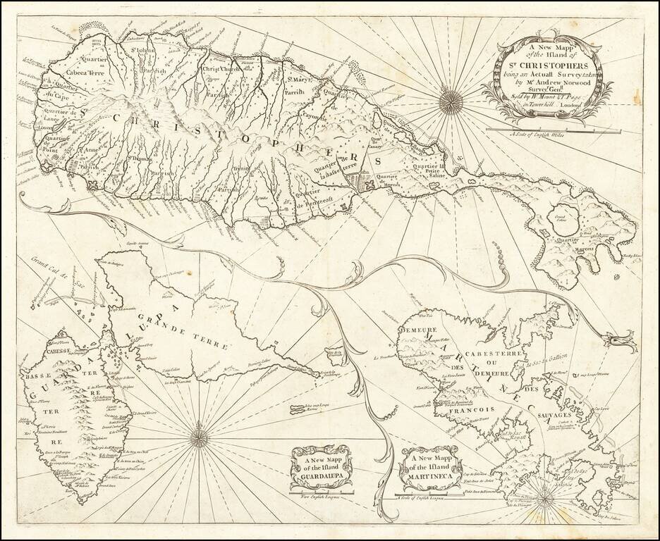
Nice example of John Thornton's sea chart of St. Kitts, Guadalupe and Martinique, which first appeared in the English Pilot, Fourth Book, in about 1706.

Includes a fine map of St. Christophers, now known as St. Kitts, showing the parishes, forts, settlements, and churches, along with two other maps on the same sheet.

John Thornton was one of the most important English mapmakers, from the so-called Thames School of chart makers, during the period when Britain dominated mapmaking. In addition to actual chart-making he also was a publisher. He was appointed Hydrographer to the Hudson Bay Company and the East India Company.

The map would later be re-issued by Samuel Thornton and later Mount & Page.


Special conditions for students!

If you are a student, write to us in telegram: @antiquemaps and indicate what material you need and for what work you need a map in high detail. We are ready to provide material on special terms. For students only!

Item information:

Year of creation:
Size:
13395x10986 px
Disk:
29.5657MiB
Number of pages:
1
Place:
London
Author:
William Mount. Thomas Page.
$14.99

Related item