logo

1852. A New Map of Virginia with its Canals, Roads & Distances from place to place , along the Stage and Steam Boat Routes . . .

  • A New Map of Virginia with its Canals, Roads & Distances from place to place , along the Stage and Steam Boat Routes . . .

A New Map of Virginia with its Canals, Roads & Distances from place to place , along the Stage and Steam Boat Routes . . . information:

Year of creation: 
Resolution size (pixels): 
 9254x7898 px
Disk Size: 
 17.4198MiB
Number of pages: 
 1
Place: 
 Philadelpha

Print information. Print size (Width x height in inches):
Printing at 72 dpi 
  128.53 х 109.69
Printing at 150 dpi 
 61.69 х 52.65
Printing at 300 dpi 
 30.85 х 26.33

An example of detailing the file of this map of in a printable high-resolution:

Click to open in high resolution (open in new tab).
Attention! this is just the central piece (central area 960x960 px) of the map file!
This is an example, so that you can see and study the level of detail of a given map. The entire Map will be fully available after payment!

A New Map of Virginia with its Canals, Roads & Distances from place to place , along the Stage and Steam Boat Routes . . .

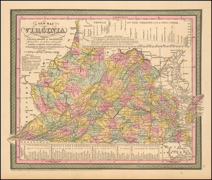
Nice example of Cowperthwait's early map of the State of Virgina, showing counties, towns, rivers, roads, mountains, lakes, Canals, etc.

Profile of the Chesapeake and Ohio Canal at the top of the map and a schedule of steamboat routes and distances at the bottom.


Special conditions for students!

If you are a student, write to us in telegram: @antiquemaps and indicate what material you need and for what work you need a map in high detail. We are ready to provide material on special terms. For students only!

Item information:

Year of creation:
Size:
9254x7898 px
Disk:
17.4198MiB
Number of pages:
1
Place:
Philadelpha
Author:
Thomas, Cowperthwait & Co..
$14.99

Related item