Map size in jpg-format: 2.17232MiB
Click to open in high resolution (open in new tab).

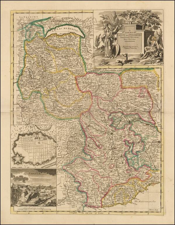
Nice example of John Senex's map of Piedmont & Savoy, from his New General Atlas.
The map includes an inset plan of Turin and a view of Verrua. Fine dark impression of this scarce map, with an ornate title cartouche.
John Senex
John Senex (1678-1740) was an important map- and instrument-maker in early 18th century London. He began his career working for the London bookseller Robert Clavell, in 1692. Senex's apprenticeship lasted around seven years, and in 1702 he was publishing under his own name, with his own premises at St. Clemen's in the Strand. He initially published perfunctory religious texts and the like. But before long he started publishing John Seller's works, and in 1705, he had relocated "next to Fleece Tavern in Cornhill." According to some sources, he moved to the area in part to fill the gap left by the 1703 death of Cornhill mapmaker, Robert Morden. At this time, Senex continued his involvement with Seller and Price, helping launch his mapmaking career. In the 30 years, that followed he would go on to become a great atlas publisher, and perhaps the greatest globemaker in the world for the period. Senex died in 1740, and his estate, including many of the copper plates for his globes, were dispersed by his heirs over the next 20 years.
John Senex (1678-1740) was one of the foremost mapmakers in England in the early eighteenth century. He was also a surveyor, globemaker, and geographer. As a young man, he was apprenticed to Robert Clavell, a bookseller. He worked with several mapmakers over the course of his career, including Jeremiah Seller and Charles Price. In 1728, Senex was elected as a Fellow of the Royal Society, a rarity for mapmakers. The Fellowship reflects his career-long association as engraver to the Society and publisher of maps by Edmund Halley, among other luminaries. He is best known for his English Atlas (1714), which remained in print until the 1760s. After his death in 1740 his widow, Mary, carried on the business until 1755. Thereafter, his stock was acquired by William Herbert and Robert Sayer (maps) and James Ferguson (globes).
If you are a student, write to us in telegram: @antiquemaps and indicate what material you need and for what work you need a map in high detail. We are ready to provide material on special terms. For students only!
![[Course of the Rhine River] Nova Tractus Totius Rheni Oder Neue beschreibung des Rhein-Strom](/map/small/58670.jpg)