Map size in jpg-format: 25.6875MiB
Click to open in high resolution (open in new tab).
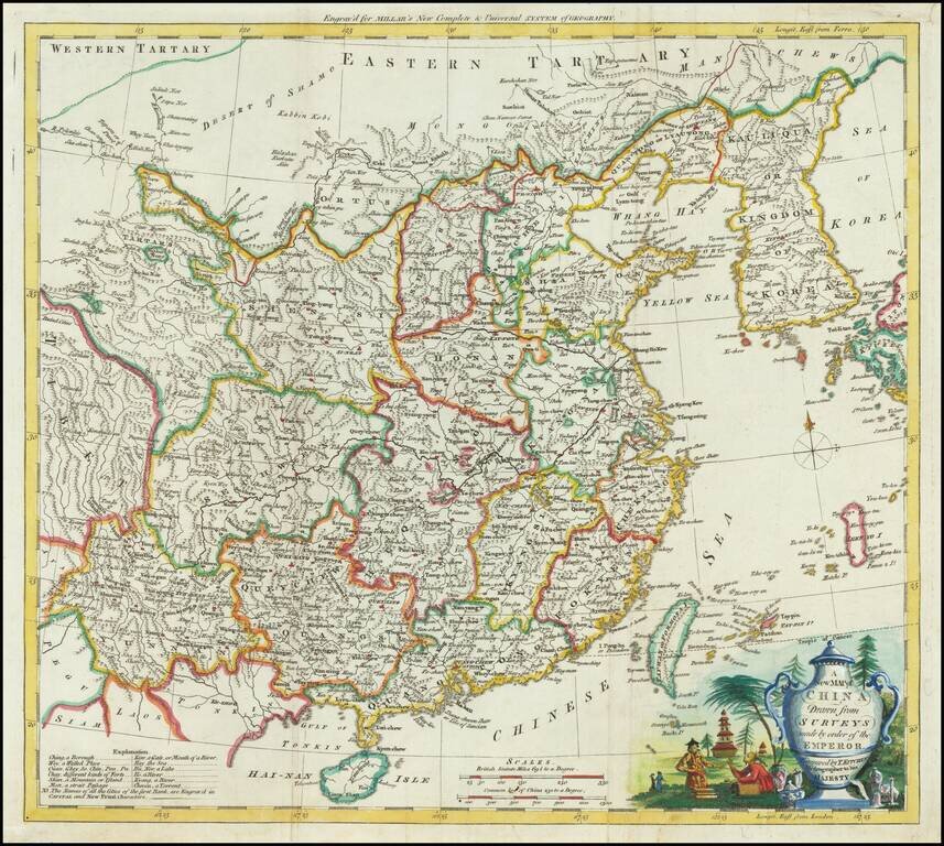
Attractive engraved map of China, produced by Thomas Kitchin for George Henry Millar's New Complete & Universal System of Geography.
The map was published in London circa 1782.
The cartouche is particularly attractive on this map, featuring a large Chinese ceramic vase for the title block and surrounded by pagodas and locals.
The "Sea of Korea" is labeled as such.
Thomas Kitchin (1719–1784) was a British cartographer and engraver. Born in Southwark, England, Kitchin was the eldest of several children. He was apprenticed to the map engraver Emanuel Bowen from 1732 to 1739, and he married Bowen’s daughter, Sarah, in December 1739. By 1741 Kitchin was working independently and in 1746 he began taking on apprentices at his firm. His son Thomas Bowen Kitchin was apprenticed to him starting in 1754. By 1755 Kitchin was established in Holborn Hill, where his firm produced all kinds of engraving material, including portraits and caricatures. He married his second wife, Jane, in 1762. Beginning in 1773 Kitchin was referred to as Hydrographer to the King, a position his son also later held. He retired to St. Albans and continued making maps up to the end of his life.
A prolific engraver known for his technical facility, clean lettering, and impressive etched decoration, Kitchin produced several important works throughout his career. He produced John Elphinstone’s map of Scotland in 1746, and the first pocket atlas of Scotland, Geographia Scotiae, in 1748/1749. He co-published The Small English Atlas in 1749 with another of Bowen’s apprentices, Thomas Jefferys. He produced The Large English Atlas serially with Emanuel Bowen from 1749 to 1760. This latter was the most important county atlas since the Elizabethan era, and the first real attempt to cover the whole country at a large scale. In 1755 Kitchin engraved the important John Mitchell map of North America, which was used at the peace treaties of Paris and Versailles. In 1770 he produced the twelve-sheet road map England and Wales, and in 1769–70 he produced Bernhard Ratzer’s plans of New York. In 1783 he published The Traveller’s Guide through England and Wales.
If you are a student, write to us in telegram: @antiquemaps and indicate what material you need and for what work you need a map in high detail. We are ready to provide material on special terms. For students only!
![[Martin Behaim Globe / Book] Pars Globi terrestris Ao. 1492 a Martino Behaim Equite Lusitano Norimbergae confecti Delineavit Christoph. Theoph de Murr 1778 (bound with:) Diplomatische Geschichte des Portugesischen berühmten Ritters Martin Behaims](/map/small/68828.jpg)
![Il Disegno Della Terza Parte Dell' Asia [Gastaldi's Wall Map of SE Asia with extra panels!]](/map/small/30554hbp.jpg)
![Chinae, olim Sinarum regionis nova descriptio. auctore Ludouico Georgio. [English Edition!]](/map/small/71123.jpg)