Map size in jpg-format: 3.51742MiB
Click to open in high resolution (open in new tab).
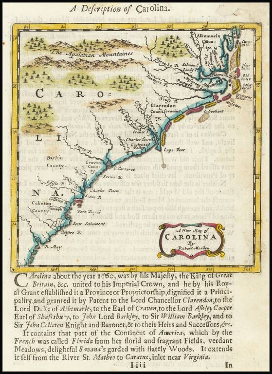
Nice example of Morden's map of the Carolinas, one of the earliest obtainable English maps of the Carolinas.
Beginning in the 1670s, the English fortunes in North America took a dramatic turn upward, resulting in a booming interest in the British American Colonies and, in turn, the issuance of maps to satisfy this interest.
The map is a reduced version of Thornton, Morden & Lea's A New Map of Carolina, published in 1685, with one significant change, the Camabh and May Rivers do not intersect inland. The map covers the region from the May River and Colleton County to the Outer Banks and Albermarle County, centered on Cape Fear. Scots Settlement, Charles Town, Charles Towne, Port Royal, Barkin County, Craven County, Clarendon County, Albermarle County and Colleton County are all named, as are the Appalachians. The Tar-Pamlico (Pantegoe) River appears. Lederer's Savana and Lake Apalachia are no longer shown.
Charleston is correctly located at the intersection of the Cooper and Ashley Rivers. The outline and angle of the coastline is significantly improved from the earlier edition of the map.
If you are a student, write to us in telegram: @antiquemaps and indicate what material you need and for what work you need a map in high detail. We are ready to provide material on special terms. For students only!


![[The First Maps in a la poupée Printed Color] Cartes en Couleur des Lieux Sujets aux tremblements de Terre Dans toutes les parties du Monde Selon le Sisteme de l’impulsion Solaire](/map/small/52293op.jpg)