logo

1852. A New Map of Arkansas with its Canals Roads & Distances . . .

  • A New Map of Arkansas with its Canals Roads & Distances . . .

A New Map of Arkansas with its Canals Roads & Distances . . . information:

Year of creation: 
Resolution size (pixels): 
 7757x9414 px
Disk Size: 
 13.7877MiB
Number of pages: 
 1
Place: 
 Philadelphia

Print information. Print size (Width x height in inches):
Printing at 72 dpi 
  107.74 х 130.75
Printing at 150 dpi 
 51.71 х 62.76
Printing at 300 dpi 
 25.86 х 31.38

An example of detailing the file of this map of in a printable high-resolution:

Click to open in high resolution (open in new tab).
Attention! this is just the central piece (central area 960x960 px) of the map file!
This is an example, so that you can see and study the level of detail of a given map. The entire Map will be fully available after payment!

A New Map of Arkansas with its Canals Roads & Distances . . .

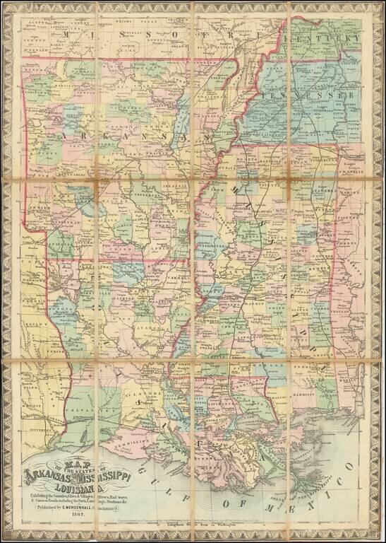
Cowperthwait's map of Arkansas, hand colored by counties, with a chart showing the Steamboat routes and illustrating canals, railroads, and other details.


Special conditions for students!

If you are a student, write to us in telegram: @antiquemaps and indicate what material you need and for what work you need a map in high detail. We are ready to provide material on special terms. For students only!

Item information:

Year of creation:
Size:
7757x9414 px
Disk:
13.7877MiB
Number of pages:
1
Place:
Philadelphia
Author:
Thomas, Cowperthwait & Co..
$14.99

Related item