Map size in jpg-format: 83.0783MiB
Click to open in high resolution (open in new tab).
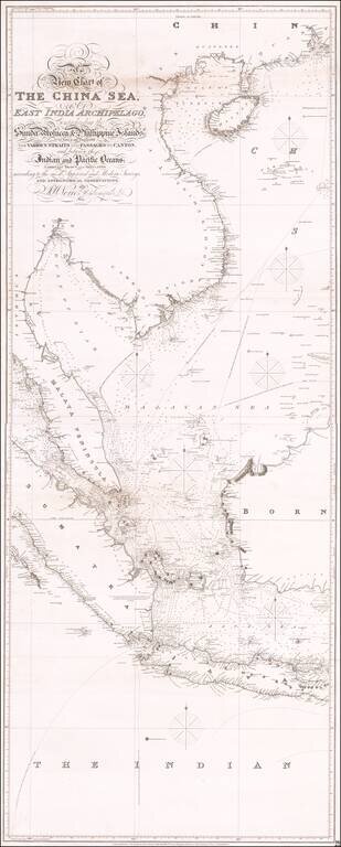
Antique Sea Chart of East Asia
Fine early sea chart of Eastern Asia, centered on Malaysia and Singapore.
One of three stand-alone images comprising the massive chart of Southeast Asia by Norie. This is the central sheet, with the engraved title and covering the area from Hong Kong to Christmas Island, including the Gulf of Siam, Malaysia, Sumatra, Singapore Java, and Batavia (Jakarta).
The map includes the Parcel Islands, Malayan Sea and sailing directions during the various Monsoon Seasons and a close passage for "Leaky Vessels."
The coastline of China south of the Pearl River and north of Hainan is still largely incomplete and partially charted south of Macoa (Macao).
Engraved by Stephenson.
Rarity
The complete chart is quite rare on the market.
John William Norie (1772 – 1843) was a publisher of nautical books held in high regard by his contemporaries. He also specialized in nautical charts and was a mathematician. Norie was born in Wapping, London, the eldest of eight children.
Norie had an apptitude for navigation and chart making. His first work was published in 1796, The Description and Use of Hadley's Quadrant, by William Heather, a chart and instrument seller. Heather then took Norie on as a chart maker and allowed him to run a nautical academy out of Heather's premises on Leadenhall Street. He continued to work for Heather, working out of his shop.
Norie published many works, but the most famous were A Complete Set of Nautical Tables (1803) and the Epitome of Practical Navigation (1805). Both were reissued throughout the nineteenth century, usually together. The Tables are still issued today. The Epitome became the standard work on navigation; it was so famous that authors C. S. Forester and Jack London both mention the book in their fiction. In addition to the Epitome, Norie wrote the The shipwright's vade-mecum (1822), Plates Descriptive of the Maritime Flags of All Nations (1838), and The naval gazetteer, biographer, and chronologist; new and improved (1842). He also provided pilots with charts that covered practically the entire world's seas--the famous blue-back charts.
Norie partnered with a financial backer, George Wilson, to buy Heather's business upon Heather's death in 1813. In addition to the nautical academy and the copyright to his books, Norie prospered from the growing business, which he managed. The shop, operating under the sign of the Wooden Midshipman, was called the Navigation Warehouse. It featured in Charles Dickens' Dombey and Son.
Norie retired in 1840. He sold his shares in the business and moved to Edinburgh. He died there, at the age of 71, on Christmas Eve 1843. His company was renamed Norie & Wilson after his retirement. In 1903, the firm merged with rivals and became Imray, Laurie, Norie & Wilson. It is still in business today.
If you are a student, write to us in telegram: @antiquemaps and indicate what material you need and for what work you need a map in high detail. We are ready to provide material on special terms. For students only!
![[Martin Behaim Globe / Book] Pars Globi terrestris Ao. 1492 a Martino Behaim Equite Lusitano Norimbergae confecti Delineavit Christoph. Theoph de Murr 1778 (bound with:) Diplomatische Geschichte des Portugesischen berühmten Ritters Martin Behaims](/map/small/68828.jpg)
![Il Disegno Della Terza Parte Dell' Asia [Gastaldi's Wall Map of SE Asia with extra panels!]](/map/small/30554hbp.jpg)
![Chinae, olim Sinarum regionis nova descriptio. auctore Ludouico Georgio. [English Edition!]](/map/small/71123.jpg)