John William Norie (1772 – 1843) was a publisher of nautical books held in high regard by his contemporaries. He also specialized in nautical charts and was a mathematician. Norie was born in Wapping, London, the eldest of eight children.
Norie had an apptitude for navigation and chart making. His first work was published in 1796, The Description and Use of Hadley's Quadrant, by William Heather, a chart and instrument seller. Heather then took Norie on as a chart maker and allowed him to run a nautical academy out of Heather's premises on Leadenhall Street. He continued to work for Heather, working out of his shop.
Norie published many works, but the most famous were A Complete Set of Nautical Tables (1803) and the Epitome of Practical Navigation (1805). Both were reissued throughout the nineteenth century, usually together. The Tables are still issued today. The Epitome became the standard work on navigation; it was so famous that authors C. S. Forester and Jack London both mention the book in their fiction. In addition to the Epitome, Norie wrote the The shipwright's vade-mecum (1822), Plates Descriptive of the Maritime Flags of All Nations (1838), and The naval gazetteer, biographer, and chronologist; new and improved (1842). He also provided pilots with charts that covered practically the entire world's seas--the famous blue-back charts.
Norie partnered with a financial backer, George Wilson, to buy Heather's business upon Heather's death in 1813. In addition to the nautical academy and the copyright to his books, Norie prospered from the growing business, which he managed. The shop, operating under the sign of the Wooden Midshipman, was called the Navigation Warehouse. It featured in Charles Dickens' Dombey and Son.
Norie retired in 1840. He sold his shares in the business and moved to Edinburgh. He died there, at the age of 71, on Christmas Eve 1843. His company was renamed Norie & Wilson after his retirement. In 1903, the firm merged with rivals and became Imray, Laurie, Norie & Wilson. It is still in business today.

Using the Stars to Understand Latitude—A Rare Instructional Star Chart Rare, commercially-published star chart, made for teaching constellations and the path of the sun through the celestial sphere, the ecliptic, to students of astronomy. Once these...

Fine Example of a Norie Blueback Chart of the Atlantic and Indian Oceans Impressive, rare example of a blueback chart of the southern Atlantic and Indian Oceans, showing the major shipping routes around the Cape of Good Hope. The chart, twice...
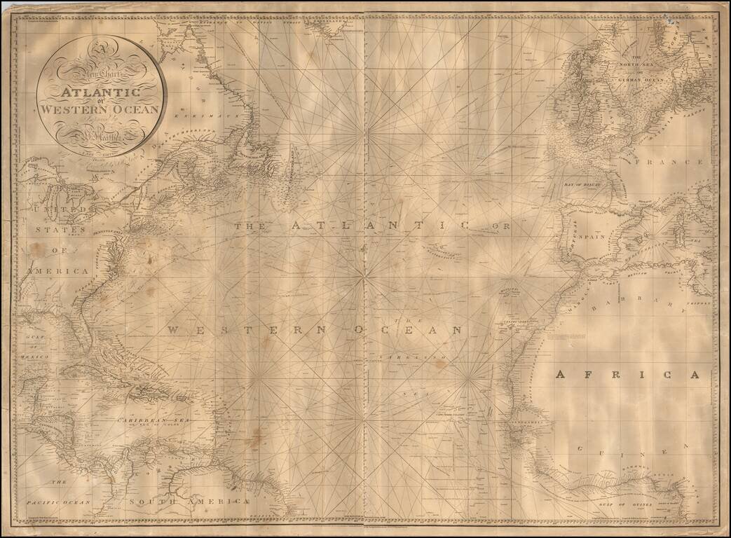
Nice example of William Heather's scarce chart of the Atlantic Ocean, offered here in a "New Edition" by John W. Norie and dated 1828. One of the best large format charts of the Atlantic published in the first half of the 19th Century, Heather's chart...
![[Right sheet only of: A New Chart of America Florida to New York with the Principal Harbours on a Large Scale, Drawn from the latest Authorities, by Robt Blachford. 1807.]](/map/small/55819.jpg)
A rare antique sea chart, probably constituting the northernmost sheet of Blachford's chart of the East Coast, but likely a Norie reissue of about 20 years later. The map features insets of Delaware Bay ("Plan of Delaware Bay and River, By Joshua...
![[Pacific Whaling] A New Chart of The Pacific Ocean, Exhibiting The Western Coast of America from Cape Horn to Beerings Strait, The Eastern Shores of Asia Including Japan, China . . . according the most Modern Surveys . . . Additions to 1836 (Large Insets](/map/small/56007.jpg)
With Manuscript Tracks Showing the Course of An American Whaler in the Pacific. Fine example of Norie's monumental sea chart of the Pacific Ocean. The chart is noteworthy for the large insets maps of San Francisco, San Diego, Hawaii, Honolulu and...
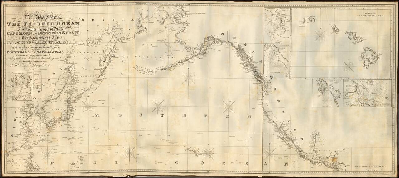
Fine example of Norie's monumental sea chart of the northern part of the Pacific Ocean. The chart is noteworthy for the large inset views of San Francisco, San Diego, Hawaii, Honolulu and Karakakoa Bay in Hawaii. Issued with revisions up to 1844,...
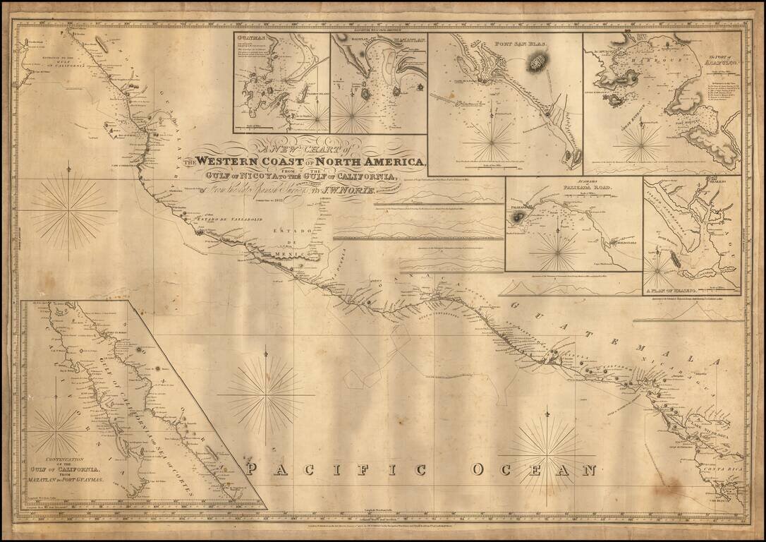
Engraved sea chart covering the area from Cape Blanco, Costa Rica, to the mouth of the Gulf of Mexico, with an inset map titled "Continuation of the Gulf of California, from Mazatlan to Port Guymas." The map includes the following harbor map insets:...
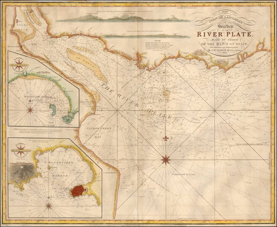
English Edition of The First Scientific Mapping of the Rio de la Plata Unrecorded 1824 edition of Norie's English Sea chart of the mouth of the River Plate, based upon Spanish surveys undertaken by the Malapsina expedition, under the direction of Juan...
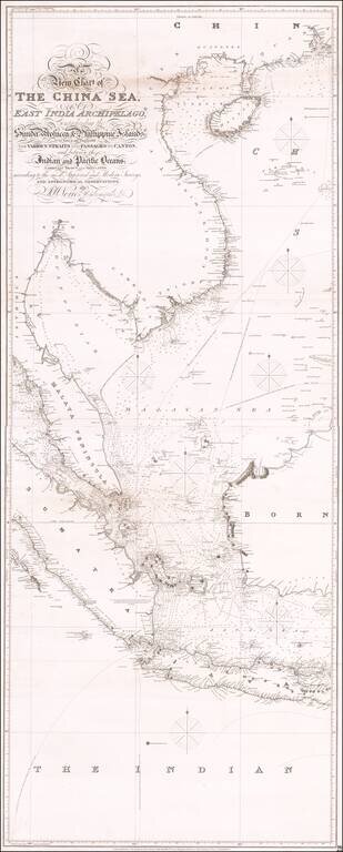
Antique Sea Chart of East Asia Fine early sea chart of Eastern Asia, centered on Malaysia and Singapore. One of three stand-alone images comprising the massive chart of Southeast Asia by Norie. This is the central sheet, with the engraved title and...