logo

1732. A New and Correct Draught of the Bay of Matanzas. On ye North side of ye Island Cuba, done from a Survey by Robt. Pearson.

  • A New and Correct Draught of the Bay of Matanzas.  On ye North side of ye Island Cuba, done from a Survey by Robt. Pearson.

A New and Correct Draught of the Bay of Matanzas. On ye North side of ye Island Cuba, done from a Survey by Robt. Pearson. information:

Year of creation: 
Resolution size (pixels): 
 8502x6638 px
Disk Size: 
 10.4435MiB
Number of pages: 
 1
Place: 
 London
Author: 

Print information. Print size (Width x height in inches):
Printing at 72 dpi 
  118.08 х 92.19
Printing at 150 dpi 
 56.68 х 44.25
Printing at 300 dpi 
 28.34 х 22.13

An example of detailing the file of this map of in a printable high-resolution:

Click to open in high resolution (open in new tab).
Attention! this is just the central piece (central area 960x960 px) of the map file!
This is an example, so that you can see and study the level of detail of a given map. The entire Map will be fully available after payment!

A New and Correct Draught of the Bay of Matanzas.  On ye North side of ye Island Cuba, done from a Survey by Robt. Pearson.

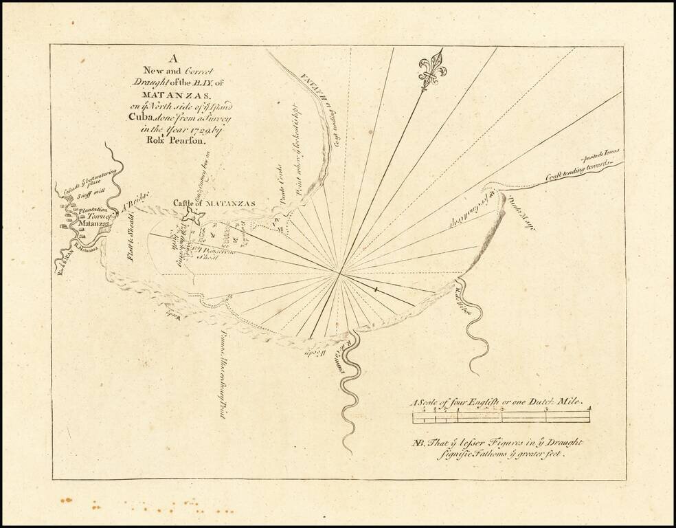
Highly detailed plan of the Bay of Matanzas on the Island of Cuba, from the English Pilot, Fourth Book, published by Mount & Page.

This detailed plan includes the location of Plantations Houses, Rivers, a bridge, soundings, anchorages and other coastal details. Includes rhumblines and a scale of miles.

The English Pilot was one of the most important and enduring privately published sea atlases. First published by John Seller in the late 17th Century, the atlas of working sea charts was expanded and published on a continuous basis by various publishers until 1803. The maps were intended as working sea charts. While mariners often complained of their inaccuracies, there is no question that they were of tremendous commercial and navigational importance during the 18th Century.


Special conditions for students!

If you are a student, write to us in telegram: @antiquemaps and indicate what material you need and for what work you need a map in high detail. We are ready to provide material on special terms. For students only!

Item information:

Year of creation:
Size:
8502x6638 px
Disk:
10.4435MiB
Number of pages:
1
Place:
London
Author:
Thomas Page. Richard Mount.
$14.99

Related item