Map size in jpg-format: 58.1603MiB
Click to open in high resolution (open in new tab).
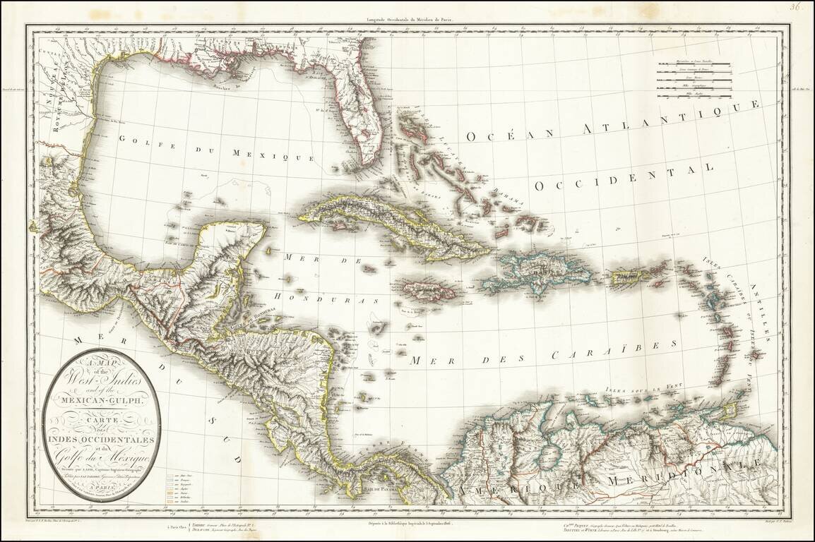
This is a rare separately issued map of the Gulf Coast and the Caribbean by Tardieu. The map was issued shortly after the Louisiana Purchase (1803) and the creation of the Mississippi Territory (1804). The map demonstrates the remarkably fine engraving characteristic of Tardieu's maps.
A number of interesting features abound on this map. In the north, two Floridas still appear on the map; West Florida would see a brief stint of independence in 1810. It is seen here extending to the Mississippi. The Bahamas are given the alternate name of the Lucayos Islands, referring to their native inhabitants. The Caribbean islands are colored according to the country of possession, typical of maps of the time. As such, Cuba and Puerto Rico can be identified as Spanish, Jamaica as English, St. Domingo as French, and the Antilles as shared by the British and French.
Texas is labeled "Nouveau Royaume de Leon".
This map was issued alongside a map of North America, with the interior of the continent based upon Arrowsmith's 1796 map. The Library of Congress owns this lower sheet, and no other institutional examples have been located in American Institutions. This is the second time we have handled this map separately from the map of North America.
Pierre Antoine Tardieu (1784-1869), also known to sign his works as PF Tardieu, was a prolific French map engraver and geographer. The Tardieu family, based in Paris, was well known for their talent in engraving, cartography, and illustration. Pierre Antoine’s father, Antoine Francois Tardieu, was an established cartographer who published numerous atlases. His son is said to have collaborated with him for many years before establishing his own independent career.
Pierre Antoine Tardieu’s most famous work includes engravings of the islands of La Palma and Tenerife, for which in 1818 he was awarded a bronze medal by King Louis-Phillipe for the beauty and accuracy of his mapping. Other famous work includes his mapping of Louisiana and Mexico, engravings of Irish counties, maps of Russia and Asia, and his highly celebrated illustrations of all the provinces of France. He was also the first mapmaker to engrave on steel.
Tardieu was a popular map engraver in his lifetime, enjoying the patronage of the likes of Alexander von Humboldt and respect among his peers. In 1837, he was appointed the title Chevalier de la Légion d’honneur. As was written in his obituary in the Bulletin of the Geographical Society of France, he was renowned for his combination of technical talent and scholarly research skills and praised for furthering his family’s well-respected name in the scientific arts.
If you are a student, write to us in telegram: @antiquemaps and indicate what material you need and for what work you need a map in high detail. We are ready to provide material on special terms. For students only!


