Map size in jpg-format: 595327B
Dynamic Maps of Cayenne and Martinique From a Celebrated Voyage Collection
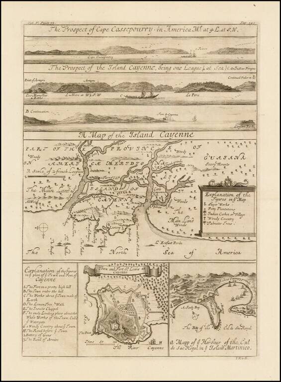
Fine set of striking copper engravings of Cayenne and Cassepouri, French Guinea, in South America, and of Martinique in the West Indies. They were included in the Churchills’ expanded travel collection, published in London in 1732.
The map of Cayenne, home of Cayenne pepper, has a key of symbols identifying the sugar works, petty plantations, an indigenous carbet or village, woody country and palmetto trees.
The plan of Fort Lewis, Cayenne also has a lettered key including, among other items, “A. the fort on a pretty high hill,” “d.the lemon tree walk,” and “f. the only landing place about the whole works of the town call'd ye watergate.”
The Churchills’ voyage collection
The Churchill brothers, Awnsham (1658-1728) and John (ca. 1663-ca. 1714), were publishers in London who catered to an affluent clientele, and they were from a prominent family themselves. A distant relative was John Churchill, the Duke of Marlborough. Two of their older brothers, Joshua and William, served as Members of Parliament. Awnsham also was elected an MP for Dorcester in the first years of the eighteenth century.
In 1704, they released the first edition of one of their most successful works, A collection of voyages and travels: some now first printed from original manuscripts, others now first published in English. The collection consisted of four volumes of voyages and travel accounts derived from primary sources in English, French, Dutch, Italian, Spanish, and German, a feat not seen since Hakluyt’s work over a century earlier.
The Churchill brothers are perhaps best-known today as the publisher of the works of John Locke. Awnsham supported religious tolerance and moderation for nonconformists, stances that would have appealed to Locke. Locke is supposed to have written the introductory discourse which opens the voyage collection.
This map appeared in the 1732 expanded edition, which extended the collection to six volumes. This item featured in the fifth volume, as indicated by the note in the upper left corner. A further edition of eight volumes was issued in 1752.
The collection was widely respected and considered one of the most prestigious examples of the genre in the eighteenth century. The maps and illustrations from the collection are relatively scarce on the market, especially given how important the publication was when it debuted.
If you are a student, write to us in telegram: @antiquemaps and indicate what material you need and for what work you need a map in high detail. We are ready to provide material on special terms. For students only!


![[Wall Map] West-Indische Paskaert waer in de graden der breedde over weder zyden vande middelyn wassende so vergrooten dat die geproportioneert syn tegen hunne nevenstaende graden de lengde.](/map/small/60169.jpg)